Reviewed by Joe Mehaffey and Jack Yeazel
(16 July 2002 - Revise some opinions)
Return to GPS Information Home Page
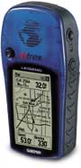
eTrex LEGEND
The eTrex LEGEND and VISTA are Garmin's latest in the low cost eTrex line. These models offer a MAPPING capability for both MapSource and MetroGuide maps. The Legend/Vista is the first of Garmin's new product line to offer built in (WAAS) which improves position measurement accuracy. The VISTA and VENTURE models offer more and less functionality then the mid range LEGEND. Selected screen shots are shown (HERE)
NOTE: Apparently most Vistas are being delivered with the contrast very low. If you can't read the screen, activate the GPS, wait 30 seconds (until the satellite screen is presented), press and hold the upper left (zoom-out) key until the contrast is acceptable. The zoom-in key will decrease the contrast.
What's New and Different in the eTrex
LEGEND, VISTA and VENTURE?
The Garmin eTrex
LEGEND (street price ~$225 version 2.00), VISTA (street price
~$300), check latest prices (HERE),
is an upgraded eTrex package with the addition a "click stick" switch to
the upper left of the screen along with the position augmentation
of WAAS. Many have reported this click stick difficult to enter keystrokes
accurately. The new high resolution display is 160 x 288 pixels and is
difficult to read because the text is so small.
While the Magellan 330 has the capability for WAAS, LEGEND/VISTA are the first Garmin model GPS receivers to offer this capability. Now the GPS-V and GPSmap 76(S) have WAAS capability.
The LEGEND model does not have the compass and aneroid barometer included in the VISTA model which is otherwise similar. The Vista includes a barometer similar to the Summit (reviewed HERE). Legend and Vista come pre-loaded with Garmin's Marine Navigation Aids POI. The VENTURE model is essentially identical to the LEGEND but has NO MAPS but does have 1 meg of POI (Points of Interest) data included as does LEGEND. Functionality is otherwise identical to LEGEND. The eSeries in general have eliminated the "Remarks" feature from waypoint names. However, the Legend and Vista allow 10-character waypoint names as compared to 6 characters in the eTrex and eTrex Summit.
BAROMETER:
The VISTA barometer is a potentially useful for some people as it
is used to compensate for the normal fluctuations in GPS altitude.
However it has some problems, because it causes Altitude to not readout
properly
in pressurized airplanes. Although the unit's barometer
is supposedly corrected by the GPS altitude, there is no evidence that
this is so. For example, if one increases altitude, the Barometer
pressure goes DOWN (and vice versa) when the Barometer pressure has actually
not changed at all. Also, one cannot read the GPS altitude on a continuous
basis. Read Garmin's explanation of the VISTA barometer (HERE).
All these barometer problems have been corrected in the GPSmap 76S which
you can read about (HERE).
TRACKLOGS: The LEGEND, VISTA and VENTURE share with other eTrex models the highest resolution tracklogs while walking of any Garmin series. See plots (HERE). Compared to the Summit, the Legend default has less walking resolution. However, the Auto tracklog interval can be set to "More Often" or "Most Often" to increase tracklog resolution. Selected saved tracklogs can be displayed on the map page. Saved tracklogs also show the enclosed area. One saved track at a time can be converted to a Trackback. Note: With LEGEND, VISTA, and VENTURE, the user has control of the tracklogger as to automatic/time/distance between log points unlike earlier eTrex models. For some tests of the Vista's accuracy with WAAS see (HERE).
ROUTES and MAPS: Vista and Legend can upload ALL of Garmin's digital mapping products. (VENTURE has no built in or uploadable map capability.) The Legend and Vista do not have built-in automatic address-to-address routing. However, with Garmin's new MetroGuide USA, best routes CAN generate automatic address-to-address routes on your external computer which can then be uploaded into the Legend and Vista. Delorme SA8 also can provide the address to address routing function for uploading into LEGEND/VISTA.
What about LEGEND's regular GPS features?
The eTrex model series are designed with a new "non technical" GPS
user in mind. However, the Vista and Legend have a
complete feature set for hiking and motoring. When MetroGuide maps
are loaded, a FIND ADDRESS feature allows location of a particular
street address and you can MANUALLY generate a route to this address by
placing waypoints at each intersection on the way and connecting the waypoints
into a route. Standard features of Legend and Vista include: Sun
and Moon predictor, Calculator, and "Best time to hunt and
fish". Garmin's new Fishing Hot Spots maps also is not compatible
with LEGEND/VISTA.
Other new features of interest are:
Software Compatibility
The following programs are compatible with Garmin's data-transfer
protocol: MapSource 3.0x, Street Atlas 8, National Geographic Topo!,
Fugawi, MacGPS Pro, Ozi Explorer, G7ToWin, GARTrip, GPS Utility, and TrackMaker
Ver. 10. NMEA output is 0183 Ver 2.3.
NOTE: Only Garmin maps in conjunction to MapSource are uploadable to the mapping GPS receivers. No maps from any other vendor besides Garmin can be loaded INTO any Garmin GPS. (Same with other consumer GPS vendors.) No Scanned Map from any third party source can be loaded into any Garmin GPS receiver (Same with other consumer GPS vendors.) No USGS DRG map can be loaded. Delorme SA products cannot load maps into any vendor's GPS receiver.
Well.. What do we think about
eTrex LEGEND and VISTA?
Jack and I are always interested in new models. These offer
almost everything a hiker/motorist needs to navigate. The missing
ingredients for motorists is a readable screen, easy-to-use keys, and automatic
address-to-address routing which is available in the Garmin GPS-V and StreetPilot
III. The FIND (address/intersection/city/etc.) feature works as a
nice substitute. For hikers, we think Garmin has a nice light
units that has all essential features and more.
The LEGEND and VISTA units offer a wide range of useful features. The click stick is a potential problem as compared to the older eTrex and Summit side buttons. We still miss the full page "highway" display of cross track error which is most useful in flying and marine uses. The VISTA unit has useful and interesting elevation profiling features that will be of great interest and use to hikers, glider and soaring enthusiasts, and private pilots among others. These Vista elevation features include a "trip profile" in elevation much the same as your bread crumb trail gives you an (x,y) profile of your horizontal travels. In addition, altitude data is stored as a part of the tracklog so you can do post trip analysis on your voyage in (x,y,z) coordinates.
On the other hand, the "not included" features we like to use in other Garmin GPS versions include: external antenna port, waypoint averaging, and internal wide range voltage regulator. Map memory is 8 megs in LEGEND, 24 megs in VISTA and is NOT expandable.
WAAS: What is it and why would
I want it.
WAAS is a position accuracy enhancement system being tested (now)
for full deployment (in years to come) as a safe and reliable source of
differential corrections and integrity monitoring for aircraft navigation
system using GPS. (See more information on WAAS (HERE).
In our "casual" testing, we found that the LEGEND gave us routinely
accurate measurements only as long as there were no surrounding trees.
There were many "outlier points" in this environment out to about
42 feet. (That is why GPS accuracy is specified as 95% confidence.)
This accuracy with a good strong WAAS signal CLEAR OF TREES was about the
same error as compared to a DGPS equipped consumer model GPS receiver.
Note Carefully: Your geographic location and terrain has EVERYTHING to do with WAAS working for you. The availability of a WAAS satellite and data available is shown by a "D" on each satellite signal bar where satellite WAAS correction data is available. Presently there are only TWO WAAS satellites. ( Garmin units allow for 19 WAAS/EGNOS/MSAS unique GEO satellites as specified by the FAA. They are depicted on the GPS as Satellite ID 33-51 which is actually a NMEA convention. Each WAAS/EGNOS/MSAS satellite will have its own unique PRN code assigned from the list of 19.) Sample plots of WAAS accuracy with the VISTA are shown (HERE).
One of these is low on the SE horizon from the Eastern USA and the other low on the SW horizon in the Western USA. If you cannot see at least ONE of these WAAS satellites, WAAS will not operate. You can forget WAAS coverage at present in tree cover, mountainous terrain, or city canyons or in any other situation where you do not have a CLEAR view of one of the two WAAS satellites. Note: The FAA is expected to provide additional WAAS signals in the future, but NO TIME FRAME for these additions has been established as of February 2001. In "northern and middle America" Garmin advises that WAAS operation may be spotty at best until the FAA provides additional satellite signals. WAAS at this time is not available with Europe's EGNOS, nor is it available outside the USA.
WAAS in a nutshell: It works just fine when you are in the clear with a good view of the WAAS satellites. When you do NOT have a CLEAR view of one of the WAAS satellites, your Legend or Vista will operate as an ordinary GPS. The Legend with WAAS ON is less accurate without a clear view of the sky than with WAAS OFF. However, the VISTA's WAAS feature improves the accuracy somewhat under these conditions.
Is it a quality, and functional GPS
receiver for Hiking and Automobile use?
We do agree that eTrex LEGEND and VISTA is easy to learn,
not-so-easy to use, but fully functional in getting you from A to B.
It is accurate and provides all necessary functionality for hiking use.
Also unique is the 3,000 trackpoint storage capability. Saved tracklogs
can also double as Trackback routes once you have been along the desired
path one time. The extremely small package coupled with average
battery life. Battery life was measured at 11 hours for the Vista,
15 hours for the Legend, and 15 hours for the Vista with the compass turned
off.
eTrex and eTrex Summit both have a computer interface so a user can operate it with a mapping program such as Street Atlas, GARtrip, G7ToWin, or OziExplorer. Note: Presently, eTrex does NOT have the Garmin PVT protocol interface to computers while the eTrex Summit, Venture, Legend and Vista do have PVT protocol. We are advised that eTrex will be updated in a future firmware release to incorporate the PVT protocol.
What about RF sensitivity and use under
tree cover?
We noticed in comparative testing that our test LEGEND unit seemed
to be somewhat less sensitive than some other Garmin receivers, because
the Legend and Vista have smaller antennas than say the GPSmap 76(S) and
G-V with which we compared. Perhaps Garmin has further improved the
noise figure in the newest receivers. Experiments under tree cover
show all the eTrex models to have more reception problems than other Garmin
receivers. Data scatter due to trees is about the same.
Is eTrex Summit ROBUST? Is it
WaterProof?
The Summit is indeed a robust GPS receiver and like other Garmin
units in current production, it is rated for submersion to 1 meter
for up to 30 minutes. We did not try the submersion but Garmin has
a reputation of replacing or repairing any unit found to leak. Summit
(built same as VISTA and LEGEND) seems particularly robust and several
drops to the floor or ground did not faze it. (Such tests are NOT
recommended.)
There has been discussion as to the degree of "waterproofness" of Garmin GPS receivers and especially the eTrex and Summit (Legend and Vista use essentially the same package). Here is Garmin's statement on waterproofness:
Garmin reports: "Our specifications for eTrex are that it is waterproof per IEC529-IPX7. IEC is a European specification published by the International Electrotechnical Commission. It is very similar to the Japanese Industry Standard JIS-8. IEC529 gives an excellent breakdown of the relative degrees of protection against water ingress. (IEC529 specification can be found HERE.) (A layman's breakdown of IEC529 can be found HERE.) By the way, our products are more waterproof than virtually everyone else's. We even test 100% of them in our factory. It costs a lot more, but we do it anyway to be sure what we ship meets IPX7. We understand and acknowledge that the marine environment can be very harsh. Even the brass contacts with nickel plating and gold over that will eventually corrode if left exposed to sea water long enough. That's the best contact material available, and we use it on all our external power contacts. All other marine electronic products in the $100-$500 class that we are aware of have this weakness. IEC529 specifies that the immersion test is to be done in fresh water, probably for this reason. The harsh environment does occasionally cause failures and we continually work on improvements to existing products while introducing new ones."
"The classification of IPX7 is for temporary (i.e. accidental) immersion
in water. It is not for continuous underwater use. If the end
user is looking for something that can be used underwater continuously,
they need to find something rated IPX8 or JIS8. However, we are not
aware of any GPS or fish finder that is rated for IPX8 in any price category.
You will see in the attached sections of IEC529, that "The manufacturer
of the equipment should be consulted to determine the degrees of protection
available and the parts of equipment to which the stated degree of protection
applies." We recently did start to add to our packaging a note concerning
the extended waterproofness of our battery compartments as the seal is
rubber and over time and wear and tear, will not be able to maintain as
good of a seal as when new. We have a vested interest in presenting
truthful, correct information to all of our current and potential customers."
(End of Garmin statement.)
eTrex VISTA Feature Highlights
(In addition to the LEGEND and VISTA features described above)
Elevation Profiling features available
in the Garmin Summit and GPSmap 76..
- Real time plot over time and distance (screen
photo here)
- Zoom in/out elevation profile
- Review individual elevation points with time and date
- Current ascent/descent rate
- Total ascent/descent (resetable)
- Average ascent/descent rate
- Min/Max ascent/descent rate (resettle)
- Min/Max elevation (resetable)
Barometric Altimeter Features
- Accuracy: 10 feet with proper calibration (user and/or automatic
calibration)
- Resolution: 1 foot
- Range: Ð2,000 to 30,000 feet
- Pressure: 12 hour automatic pressure trend recording (screen
photo here)
Sight 'N Go
- Sight and locked in a bearing
- Navigate along course by following CDI with off course information
(screen photo here)
- Sight and project a waypoint, and navigate to it
Track Log
- Automatic elevation and track logging (3000 points)
- Save up to 10 tracks (along with elevation profile) with 250 points
each
- Note: Clearing track log will also clear elevation profile
Options/Settings (Both Vista and Legend)
- Option to show/hide waypoint
- Option to display heading using big numbers
- Option to set different units for distance/speed, elevation, and
pressure
- Options to turn on/off GPS and Compass (saves power when entering
data)
Electronic Compass
- Accuracy +/- 5 degrees with user calibration
- Resolution 1 degree
- Built in LEVEL sensor aids compass reading accuracy.
- Compass operates in Track UP mode only.
- Automatic Declination adjustment with manual override.
Standard LEGEND and VISTA GPS Features:
- Automatic map rotation (toward your heading, aka Track UP)
or North UP. (VISTA Compass disabled in North UP mode.)
- Create new waypoint by projecting from an existing waypoint
- 500 Waypoints (with Icons/graphic symbol, and name)
- 20 reversible routes with up to 50 waypoints in a route.
- Trip Computer with current speed, average speed, sunrise/sunset,
max speed, trip timer and trip odometer
- 108 map datums
- Position format has Lon/Lat, UTM/UPS, Maidenhead, MGRS,
and other grids, one USER grid, and one USER
Datum.
- Receiver is 12 channel parallel and operational with the WAAS
system.
- WAAS accuracy is in the range of +/- 3 meters 95% confidence,
BUT this is NOT in the specification so don't count on it.
- Antenna is slightly smaller than on larger Garmin units but it
gives sensitivity almost equal to the larger Garmin receivers.
- Receiver update rate is 1 per second.
- No external amplified antenna connection port is available.
- Acquisition Times: Warm ~15 sec, Cold ~45 seconds, AutoLocate
~2 minutes (Autolocate time was ~ 3 minutes our one test.)
- LEGEND and VISTA have only 6 control buttons, one
a rocker switch. This makes for easy one hand operation.
- Position Accuracy Specification 15 meters RMS (seems to do this
routinely with SA OFF and 3 meters RMS with WAAS signal.)
- Speed Accuracy specification 0.1 knot RMS steady state
- Interfaces: RS232 with NMEA 0183, RTCM 104 DGPS data format and
proprietary GARMIN
- Physical Size: 4.4"H x 2.0"W x 1.2"D (11.2 x 5.1 x 3.0 cm)
- Weight: 6 ounces (170 g) with batteries
- Display: 2.1"H x 1.1"W (5.4 x 2.7 cm) high contrast LCD (160
x 288 pixels), FSTN, 4 level gray scale, with
bright backlighting
- Case: Waterproof to IEC 529 IPX7 standards (Immersion to 1 meter
for 30 minutes)
- Temperature range (operation): 5°F to 158°F (-15°C
to 70°C)
- Data storage: Indefinite; no memory battery required
- Power Source: 2 AA batteries ( batteries not included in
package)
- Battery Life: Up to 11 hours (typical use) 15 hours with the compass
turned off.
Specific questions answered:
How many datums does it have? over 100
What is the battery life for the Legend?
Garmin says "up to 15 hours". We measured 13 hours, 20 minutes on
one test with our prototype unit.
Production units are supposed to run about
15 hours on Normal and 22 hours on "battery save" mode..
Does it support UTM/UPS?
Yes. MGRS? Yes.
How many backlight steps does it have?
2 (on and off) and it times out automatically in 15, 30, 60, 120
seconds or never..
Does it have user grids? Yes.
Can it measure distance between waypoints
in a route? yes
What is battery life of eTrex? About 20
hours in battery save mode on two batteries.
What is battery life for eTrex Vista?
16 hours in battery save, about 11 hours if compass is turned ON.
Can I upload all types of MapSource maps?
Yes
Can I upload all types of Metroguide maps?
Yes
Can I upload City Navigator maps for USA
and Canada? Yes, but automatic routing will not work.
What OTHER brands of maps can I upload
into my VISTA or LEGEND aside from Garmin furnished maps? None.
Does the above mean I CANNOT upload Delorme
maps to my GPS? Yes it does. Can I upload USGS maps?
No.
Can I load Magellan or Lowrance maps into
my Garmin GPS? No. Microsoft AutoRoute maps? No.
Do you mean to say that I cannot load ANY
maps except those furnished by Garmin? Yep.. Now you understand.
Can I use an external antenna? No
(except the Tri-M re-radiating antenna.)
Is there a power/data cable so I
can hook up my computer and external power to the eTrex? Yes.
What is the max external voltage
input to eTrex/Summit/Legend/Vista? Ans.: 3.25 volts DC.
( Observe POLARITY! Must have regulator if used with 12v car.)
How many map sections can I load
into a LEGEND or VISTA? up to 540 if memory space is adequate.
Does the VISTA or LEGEND have an
audio alarm? No.
Does the VISTA and LEGEND allow me
to turn "Road Lock" on and off? Yes.
Does the VISTA and LEGEND "lock"
the routes to roads like StreetPilot models? No.
Do the VISTA and LEGEND allow you
to FIND cities, intersections, addresses on both the user map and
the basemap? Yes.
Are there any special requirements
to use WAAS? Yes. You must turn Power Save OFF and RTCM IN
must not be active.
Technical Questions? Comments? Additional Info we should add?
Contact: Joe Mehaffey
- Jack Yeazel
For: How Do I operate my GPS? See: news:sci.geo.satellite-nav