WAAS and its Relation
to Enabled Hand-Held GPS Receivers
26 Feb. 2006 (Revised 19 Mar.
2012)
For a discussion of DGPS
and Technical WAAS issues, see (HERE)
Statement from the FAA
WAAS is based on a network of approximately 25 ground reference stations
that covers a very large service area. Signals from GPS satellites are
received by wide area ground reference stations (WRSs). Each of these precisely
surveyed reference stations receive GPS signals and determine if any errors
exist. These WRSs are linked to form the U.S. WAAS network. Each WRS in
the network relays the data to the wide area master station (WMS) where
correction information is computed. The WMS calculates correction algorithms
and assesses the integrity of the stem. A correction message is prepared
and uplinked to a geosynchronous satellite via a ground uplink system (GUS).
The message is then broadcast from the satellite on the same frequency
as GPS (L1, 1575.42MHz) to receivers on board aircraft (or hand-held receivers)
which are within the broadcast
coverage area of the WAAS. These communications satellites also
act as additional navigation satellites for the aircraft, thus, providing
additional navigation signals forposition determination.
The WAAS will improve basic GPS accuracy to approximately 7 meters
vertically and horizontally, improve system availability through the use
of geostationary communication satellites (GEOs) carrying navigation payloads,
and to provide important integrity information about the entire GPS constellation.
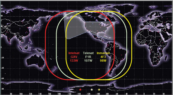
At present there are three geostationary satellites serving the WAAS area.
See graphic below.
----------------------------------------------------------------------------------------------------------------------
The European area will eventually be served by two Inmarsats, AOR-E
(Atlantic Ocean Region-East) and IOR (Indian Ocean Region) and the European
Space Agency satellite, ARTEMIS. The footprints of all but ARTEMIS
(Aircraft-Based Augmentation System) is shown below. On the future
ARTEMIS satellite, the GPS/GLONASS augmentation is made directly from aircraft
based equipment. Japan will be served by the MSAS system. The
first MSAS satellite was lost on launch.
EGNOS & WAAS do not currently share almanac information, and
EGNOS is broadcasting a "do not use" indication. So it is unlikely
that users in Europe will see any response from EGNOS until their systems
share more information and allow use of the corrections.
WAAS Information site: http://www.nstb.tc.faa.gov/
Garmin units allow for 19 WAAS/EGNOS/MSAS unique GEO satellites as
specified by the FAA TSO C-146. They are depicted on
the GPS as Satellite IDs 33-51 which is actually a NMEA convention.
Each WAAS/EGNOS/MSAS satellite will have its own unique PRN code assigned
from the list of 19. The WAAS satellites are shown on the GPS satellite
page with an ID below. These satellites do not move on the screen
as do the other GPS low-earth-orbit satellites. A short comparison
of WAAS hand-held accuracy is shown (HERE).
Garmin receivers use one or two channels to track WAAS satellites
and they will use the WAAS satellite in the position solution, if the WAAS
system indicates it is OK to use for navigation (sometimes the WAAS satellite
is flagged as "do not use for navigation" but the corrections are still
useful).
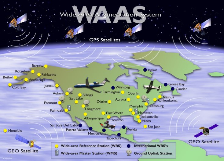
WAAS reference stations
for the USA. WAAS coverage is approximately 200nm around these stations
Another map of the WAAS service area
is at: http://www.nstb.tc.faa.gov/RT_VerticalProtectionLevel.htm
This map concentrates
on the Vertical Protection Level -the most important measure for enroute
aircraft
WAAS GEO Coverage Starting in Fall
of 2010
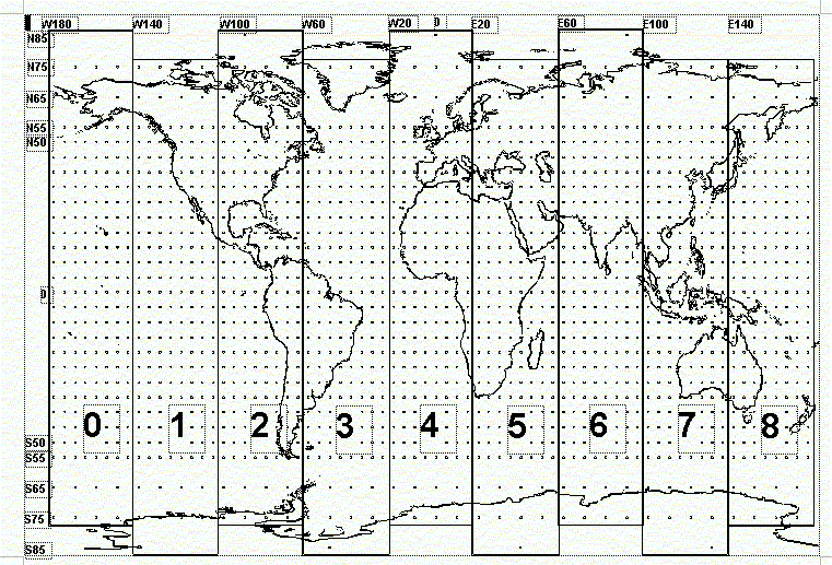
A global map which is not quite up
to date is shown (HERE)
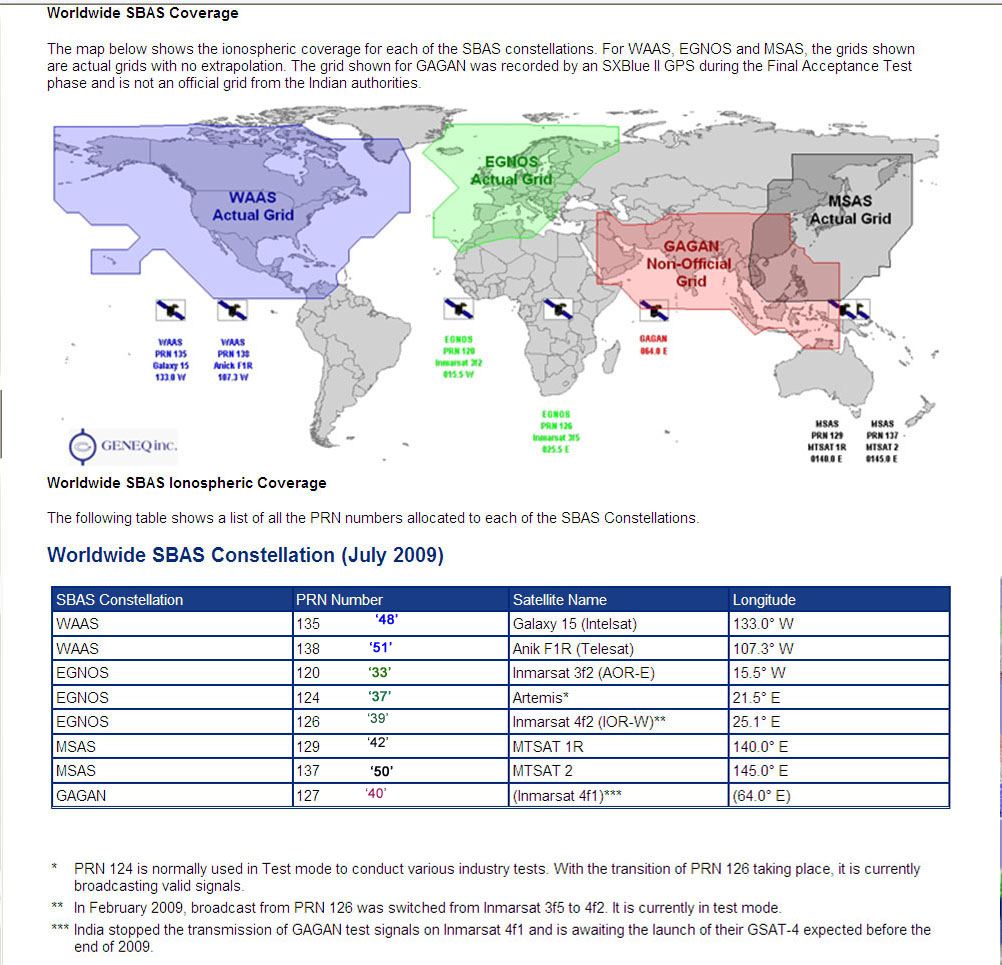
Here is the PRN/Satellite ID information for WAAS
and EGNOS
NOTE: The satellites IDs are the PRN numbers less
87.
The following PRNs have been allocated to the WAAS system:
Geostationary
PRN NMEA Satellite ID
Longitude
Inmarsat
133
46
98°W
Galaxy
15** 135
48
133°W
Anik
F1R## 138
51
107°W
** Has drifted out of orbit
## Check (HERE) to see the elevation
angle to expect on your unit in the US
The following PRNs have been allocated to the EGNOS system:
AOR-E
120
33
15.5°W
Artemis
124
37
21.5°E
IOR-W
126
39
25.1°E
IOR-E
131
44
?
The following PRNs have been allocated to the MSAS system:
MTSAT-1
129
42
140°E
MTSAT-2
137
50
145°E
The following PRNs have been allocated to the GAGAN system:
127
40
82°E
128
41
55°E
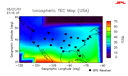
A Typical Ionospheric-delay Map of the US as Computed by the "GPS
Receiver" Sites from all received GPS Signals
A moving graphic of the daily ionospheric delays can be seen (HERE)
Ionospheric Corrections:
The IONO information transmitted by the WAAS system is much more
accurate than the basic GPS IONO model. Also, the WAAS system will
generally be more accurate than beacon based DGPS because of the way the
corrections are rendered by the WAAS system and applied by the GPS receiver.
The primary factor is spatial decorrelation, which is the degradation of
corrections due to separation from the reference station. RTCM based
DGPS corrections suffer from spatial decorrelation, but WAAS corrections
do not.
This Iono data (and other corrections) are constantly uploaded to
the Geo Sats for re-transmission to GPS navigation receivers. There
is no interpolation between ground stations by the receiver. This
is because the WAAS master system computes a "grid
of Iono corrections" which are location dependent based on the user's
position. There is an interpolation/extrapolation process to determine
the iono correction, but it is not specifically related to the location
of ground stations that collect the information. The Iono-corrections grid
offered by WAAS are interpolated and applied by the receiver.
GPS receivers must then apply the data for corrections appropriate
at their location. This may take five or ten minutes to complete
in a typical receiver.
Here are some interesting links:
http://waas.stanford.edu/~wwu/rfuller/iongps98/sld001.htm
Some encouraging results using aircraft testbeds
The FAA 727 performed a series of Category I precision approaches to the
runway at Keflavik, Iceland Airport using onboard equipment that received
signals from the FAA's National Satellite Test Bed (NSTB), which is a forerunner
to WAAS, and the United Kingdom's (U.K.) Northern European Satellite Test
Bed (NESTBed). An Iceland Civil Aviation Administration (ICAA) Beechcraft
King Air 200 and a U.K. National Air Traffic Services BAC 1-11 also performed
Category I approaches using signals from both systems. Category I approaches
are used primarily in bad weather where the pilot must see the runway at
no less than 200 feet above the ground and at a distance of one-half mile.
EGNOS tests in Europe
The NESTBED results for positioning accuracy gathered during flight trials
are promising. Corrected position results show: 95% of horizontal errors
less than 2.5m and 95% of vertical errors less than 4.5m, well within the
requirement for CAT 1 aircraft landing (CAT 1 is the less demanding of
3 categories or precision approach [ie. landing] for aircraft, where guidance
must be provided to a Decision Height of between 200 and 350 feet above
the runway at a range of 1 mile).
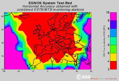
Map of EGNOS Coverage and Estimated Accuracy
Jack
Yeazel