An 'Advanced' Small Entry-Level GPS Receiver -Jack Yeazel (3 June 2003)
Read Personal Experiences with the Unit by Frank Van Hooft (HERE)
And an Update from A. C. Hurst (HERE) 12 Apr. 2008
Generally speaking, the unit's user interface is very self-intuitive. However, activating the WAAS mode was something of a puzzle. The manual (apparently) doesn't explain how to turn WAAS on. Eventually it was discovered that: Menu, Setup, System, GPS Mode, select WAAS, -will activate WAAS.
So, what's different from the geko 101?
101 201
Waypoints:
250 500
Trackpoints:
3,000 10,000
Saved tracks:
0 20
Map Datums:
18 100, 1 user
Position Accuracy: <15m
<3m (WAAS)
Data jack:
No Yes
WAAS:
No Yes
Routes:
No 20 reversible x 125 legs/route
Games:
No Yes
Antenna jack:
No No
Waypoint averaging: No
No
Adjustable
track inteval
No Yes
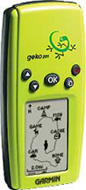
Controls:
The geko has five buttons, On/Off, Page,
Up,
Down,
and "OK" (enter). All are easy to use with one hand.
Main Pages:
All of the information needed to operate the geko 201 is found on five
main pages (or display screens). These pages are the Satellite,
Map,
Navigation,
Trip
Computer, and Menu. Pressing the
PAGE
button to switches between pages.
NOTE: The geko 201 has a Trip Computer page not available in the 101,
1) Trip Computer Page Options:
• Elevation—the measurement of height above mean sea level.
• Heading—the direction you are traveling.
• Lat/Lon—the current GPS position.
• Location—shows your current latitude and longitude.
• Max Speed—the maximum speed traveled since last reset.
• Moving Avg—(Moving Average) the average speed while the unit is moving.
• Odometer—a running tally of distance traveled, based upon the distance
between second-by-second position readings.
• Over’l Spd—(Overall Speed) the averaged speed since your last reset,
including stopped and moving time.
• Speed—shows how fast you are going.
• Sunrise—the time at which the sun rises on this day at the specified
location.
• Sunset—the time at which the sun sets on this day at the specified
location.
• Time of Day—the current time for the selected time zone.
• Time-Moving—the time elapsed while the unit is moving since the last
trip reset.
• Time-Stop—the time elapsed while the unit is not moving since the
last trip reset.
• Time-Total—the total time you have traveled since the last trip reset.
• Trip Odometer—the total distance you've gone since the last reset.
• Vert Speed—( Vertical Speed) the rate of altitude gain/loss over
time.
The following fields display figures only when navigating:
• Bearing—the compass direction from your location to your destination.
• Course—the direction from your starting location to a destination.
• Final Dest—(Final Destination) the last waypoint on your route.
• Final Distance—the distance from your current location to your destination.
• Final ETA—the estimated time you will arrive at your destination.
• Final ETE—the estimated total time left until you reach your destination.
• Next Dest—(Next Destination) the next waypoint on your route.
• Next Dist—(Next Distance) the distance between your current location
and the next waypoint.
• Next ETA—the estimated time you will arrive at the next waypoint.
• Next ETE—the estimated total time left until you reach the next waypoint.
• Off Course—the distance you are off a desired course in either direction,
left or right.
• To Course—the compass direction you must go to get back to the original
course.
• Turn—the angle difference (in degrees) from the bearing to your destination
and your current line of travel. ‘L’ means turn Left, ‘R’ means turn Right.
• VMG—( Velocity Made Good) the speed you are closing in on a destination
along a desired course. Also referred to as the ‘vector velocity’ to your
destination.
2) Satellite Page:
The Satellite Page shows (in animation), the satellites, satellite
signal strength, and the geko’s estimated location accuracy.
3) Map Page:
The Map Page shows where you are (the animated figure and provides
a picture of where you are going. As you travel, the animated figure ‘walks’)
and leaves a ‘trail’ (tracklog). Waypoint names and symbols are also shown
on the map. To help you better visualize the ‘real world’, Geko automatically
rotates the map as you move, so that waypoints that are ahead of you are
always displayed in front of the animated figure. The Heading indicator
shows the direction you are heading. To see the entire trip, you
can change the map scale (from 80 feet to 800 miles) by pressing and holding
the UP and DOWN buttons.
Map Page Options:
These Options allow customizing the Map Page. Map Setup:
Allows adjusting the map settings including: Orient Map (Ahead
or Northward): When ‘AHEAD’ is selected, the top of the map is oriented
in the direction you are currently moving. When ‘NORTHWARD’ is selected,
the map is always oriented to the North.
4) Navigation Page:
The Navigation Page helps guiding to a destination. When moving with
no particular destination in mind, the Navigation Page shows direction
and speed. When moving towards a specific destination. the Navigation Page
shows the name of the location, the distance and time to go, and displays
a direction arrow in the compass ring. To navigate, simply follow the arrow.
Navigation Page Options:
• Stop Navigation: stops any’ active navigation (displays only’ when
navigating).
• Reset Max Speed: this resets the Maximum Speed achieved during a
trip.
• Reset Trip: the trip time, trip distance (odometer and average speed
are reset to zeros
Pressing the UP or DOWN button, cycles through the Data fields
at the bottom of the Navigation Page:
Average Speed—the average speed traveled since last trip reset.
Elevation—the measurement of height above mean sea level.
Heading—the direction you are traveling.
Location—shows your current latitude and longitude.
Max Speed—the maximum speed traveled since last reset.
Speed—how fast you are going.
Time/Date—the current settings.
Trip Odometer—like a car odometer, ‘TRIP ODOMETER’ tells how far you've
gone.
Trip Time—the total time traveled since the last trip reset.
5) Menu Page:
The Menu Page gives access to the geko’s essential features. With the
Menu Page one can create (Mark) and select Waypoints,
Tracks, Routes, Games, and access the System Setup
features.
UP/DOWN button functions:
• Highlight options on pages and menus
• Adjust display contrast on Satellite Page
• Zoom out (UP) and in (DOWN) on Map Page
• Cycle through data fields on Navigation Page The OK button:
• Confirms data entry or menu selections
• Press and hold to activate Mark Waypoint Page
POWER button:
• Press and hold to turn unit on and off
• Press and release to turn display backlight on and off
Battery Rundown Time:
Using the Trip-Computer Page (Time-Stopped function) in the normal
mode with WAAS activated, the alkaline batteries lasted 11hr 30min.
Accuracy: Although the geko doesn't have waypoint averaging, eight waypoints created over an accurately-known point in the clear, averaged 1.75m (5.8 feet) error with WAAS corrections.
Well.. What do we think about it?
Ans: The gekos are the smallest waterproof GPS units with the
smallest screens we have seen. The small screen may not be as much
a drawback as one would think, because there is little detail needed.
However, the unit has most standard GPS features. It appears designed
for those that need a VERY small unit and no map capability. In our
opinion, the 201 is worth the $25 extra over the 101.