Short
review, by Carlos Puch
Having
been playing around for several days with a brand new HOLUX ezFOX (also
known as GM-100) handheld mapping GPS, I'd like to post some very early
comments on the unit. HOLUX is a Taiwan based company that manufactures
a variety of GPS equipment, including this mapping unit. More information
on its products can be found on http://www.holux.com.tw/.
The Spanish importer, PROTELSA, has been helpful and Ive received my unit
at home in 24 hours (contact: acrull@cecot.es
phone: +34-93-590-1154).
General
specifications
-The
ezFOX receiver is small: only 114 x 56 x 24 mm (like a cigarette pack which
would be 1/3 longer).
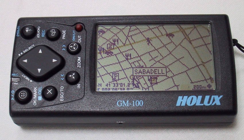
-The
screen is quite identical in size and pixels to the GIII+/G12MAP's screen
(60 x 38 mm; 160 x 100 pixels). It shows 4 levels color scale and is readable
in good light conditions. It can also be rotated from portrait to landscape
orientation with the push of a button.
-The
unit runs on two AA batteries. A couple of 1700mAh NiMH is supplied, and
a warning on the battery case advises not to use regular alkaline or non
rechargeable cells in conjunction with the supplied power cord, as it might
result in damage to the unit.
-The
square antenna is folded on the backside of the unit. It rotates to allow
for an optimal reception of the GPS signals. Once extracted, it reveals
a MCX female receptacle that accepts any of the active antennas running
on 3V.
-There's
a gap on one side of the case to insert a standard CompactFlash memory
card.
-A
power/data port is also present. It reminds the female connector of the
StarTac Motorola cell phones. (Note: the unit is not waterproof).
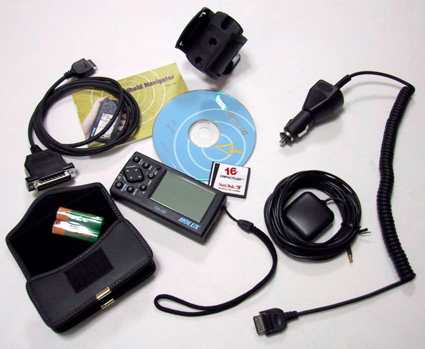
-The
full package includes (photo 1): ezFOX unit, manual / warranty card, car
bracket, leather case, data cable, active antenna (with 5 m cable), 16MB
CF memory card, cigarette adapter/charger, 2 AA NiMH 1700mA rechargeable
batteries and country map CD. Very impressive!...
Features
-12
channels receiver.
-500
waypoints (8 character length), including 12 char. comment . Waypoint symbol
can not be changed (so far).
-20
routes / 30 waypoints each.
-5
tracklogs (4 saved and 1 active), 2500 points each. Track recording mode
selectable between time and distance, an also between wrap, fill and off
options.
-Only
LAT/LON coordinates so far.
-219
datum.
-NMEA0183
serial output.
-Power
saving mode available.
Operation
-Once
powered on, the unit doesnt apparently run the traditional self-testing
sequence, as it switches almost immediately to the satellites page. Simulation
mode is available by selecting *Stop navigation* option.
-Acquisition
times are fast. Typically 75 sec. cold start, 40 sec. warm start and 15
sec. hot start. The receiver keeps track of the satellites without problem.
In urban environment it looses and reacquires the signal provided it has
a decent view of the sky. DOP number shown on the lower right of the satellites'
page is quite pessimistic if compared to the same shown on a GIII+ running
parallel. There's no EPE indication.
-Four
main pages are available: Satellites, Map, Status and Compass. A set of
menus and submenus are accessible from satellite and map pages. A main
menu can be accessed from any of the four pages.
-Satellite
page includes a polar diagram and a bar graph showing position and signal
level of the satellites being tracked; a battery gauge icon; a small bulb
indicating lighting status and the DOP indicator.
-Map
page shows the map and an arrow icon showing actual position. On the lower
right angle a graphic scale and a shadow rectangle indicating the relative
position and extent of the screen in relation to the full map loaded are
visible. The coordinates (LAT/LON) of the icon arrow appear to the left
or above the scale, depending on the screen orientation. The arrow is empty
when there's no fix and red as a position is being computed. It is possible
to pan and zoom using the cursor keys (nine zoom levels available: 100m,
200m, 500m, 1km, 2km, 5km, 10km, 20km, 50km). When panning, a cursor appears
and its coordinates are then shown. Every time a feature on the map is
reached, its name is visible inside a tiny orange hollow rectangle. Map
detail varies depending on the zoom scale selected. Maximum detail is only
visible below 500m level; this avoids screen cluttering. Theres no information
available on navigation (speed, track, etc.) in this page.
-Status
page includes a graphic strip compass on the upper side, followed by eight
cells containing numeric indication of: Speed, Track (heading), Odometer,
Trip Time, Altitude, Average Speed, Coordinates (LAT/LON) and Time and
Date. The fields aren't user configurable. Some of them may be reset.
-Compass
page shows a big compass, together with informative fields related to:
Next Waypoint, Distance to Next, Time to Next, Distance to Destination
and Time to Destination. This is the Route navigation page, and none of
the fields can be user configurable.
Maps:
-Map
information is impressive! All the roads (and some dirt roads on the countryside)
are present. There's street level maps of almost all the main and middle-size
towns in Spain (photo 2). There's also a lot of POI. A *Search Object*
menu in the map page allows for street / road, waypoints and POI search.
Map data comes from NAVTECH. At a first sight, it appears to be the same
being used by Route 66 Spain 2001 (http://www.route66.nl/).
There's no information on railroads, coastlines, rivers, lakes, forests
and urban areas despite the fact that the map page accesses one submenu
with a legend showing all those features. Portugal is included in the same
CD. Basically the maps are road/street maps sensu stricto.
-The
maps can be downloaded from a single file (in this case the whole Spain
occupies 63MB and can be accommodated into a 64MB CF card), or can be previously
merged from smaller files which, in the case of Spain, correspond to administrative
divisions (regions and provinces). The size of each file varies from around
300KB to around 5MB, depending on the area size and density. The supplied
16MB CF card can load the information needed to cover a long trip using
the merging procedure.
-The
CD-ROM contains not only the map data (split into full, wide and medium
size chunks), but also the utility needed to do the download. Also included
are the units manual in PDF format and the last firmware available (1.12EI
at this time). The download program, called MapEZ, is simple and easy to
use. Only the names of the maps are accessible so far. Theres a new version
that also displays the maps in graphic form (I will receive it during next
week from the distributor and will update this review).
-The
transfer of the maps is performed at a reasonable rate, as the supplied
cable connects to the printer (parallel) port of the PC. For instance,
the transfer of the whole map
of
Spain (63MB) took around 45 min. The transfer speed, according to the manual,
is 2.9MB / min.
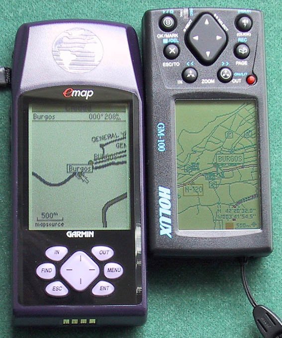
-Compared
to GARMIN Spain MapSource maps, HOLUX maps lack information on railroads,
rivers, lakes and coast lines, but the road/street information is almost
8 times more detailed. See for comparison the map of Burgos (photo 3),
a small town in the center-north of the country. (Note: the price of every
HOLUX country CD is $80; GARMIN Spain MetroGuide is $160 around here).
*First*
general impressions
This
receiver has pluses and minuses
On the positive side:
-The
satellite reception is good. The size is small. The form factor is convenient
and very useable. The choice of the standard CompactFlash card is a must
(I shift them between a Canon digital camera, a Cassiopeia PDA and the
GPS itself). The supplied leather case is nice and very protective. Also:
-Navigation
over the map seems accurate and responsive. Minor changes in speed and
direction at walking speeds are immediately detected. As the cursor moves
on the screen, the name of the street and/or the closest feature is highlighted.
Dont know so far if a dead reckoning feature is implemented on the software.
-*Search
object* menu permits a wide search in alphabetical order of cities, roads,
waypoints and POI. *Search screen* menu shows a list of features that are
visible on the actual map screen. Once selected one of the items, a page
showing its distance and bearing from actual position and its phone number
comes to first plane.
-POI
includes: City, Road, Hotel, Restaurant, Airport, Bank, Building, Car Service,
Culture, Campground, Dam, Government, Gas Station, Hospital, Harbor, Marina,
Monument, Others (bar, pub), Park, Police, Rail Station, Recreation, Religion,
Railroad, Station (bus), Sports, Scenic, Shopping and School. Some of them
arent available, at least in the Spanish maps (e.g.: Railroad, Religion).
On
the negative side:
-
A red led blinks once to confirm the correct push of every key. Nevertheless,
the keyboard in my unit is quite imprecise, resulting in errors when scrolling
and moving through the menus. Writing characters in waypoint naming menu
involves frequent typing errors as well (note that the exFOX character
set includes capitals, lower-case and signs). I insist on the fact that
this may just occur on some units like mine; I have passed this information
to the distributor and he has offered a replacement.
-Search
functions sometimes lead to unattended lockups. The only way to reset is
taking the batteries apart... From my short experience those lockups would
seem to be related to the receivers status (acquiring or simulating),
and perhaps to the screen orientation.
-The
color lines on the screen are not easy visible under poor lighting conditions;
the orientation of the unit with respect to the light source has a lot
of influence on this. The electroluminiscent backlight is clearly poor.
All
in all, the ezFOX is a reasonable option for people looking for a compact
mapping GPS. Looking at the maps, they are superb in street/road detail.
Street price in Spain for the full package is $640 (bear in mind this is
Europe, not the U.S.!). A similar GARMIN solution (eMap + 16MB data card
+ MetroGuide CD + cigarette cable + data cable + carrying case + dash-mount
support + active external antenna) is by far more expensive