MapSource Roads & Recreation CD Maps Compared with Lowrance CityStreet Maps
 (10 Feb. 1999)
City map views compared

________
      R&R                  GM-100                        R&R                GM-100                       R&R                GM-100

The above picture pairs are in the North Atlanta area just South of Sandy Springs.  The R&R and GM-100 pictures are screen dumps using G7to(w).  All of the pictures are done using user-uploaded maps from CD.  The R&R pictures are screen dumps of the Garmin G-III+ and the GM-100 pictures are using the Lowrance CityStreets CD maps.  Both GPS receivers are adjusted for the highest map resolution and detail available in all pictures.  Obviously,  one might wish to reduce the map resolution in both units for the larger scale maps.

The R&R maps puts somewhat more *road* detail (vectors per curve) on maps as compared with the GM-100, but the GM-100 has more water features.  If you place the pointer on a small residential street,  the G-III+ will put a name on the street *most of the time* without having to zoom in to see it.  (The GM-100 does not have this ability).

==============================================================================
 

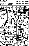
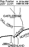
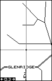
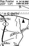
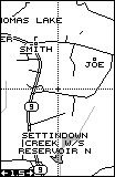
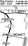
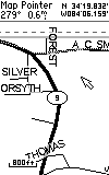
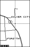
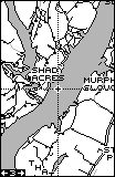
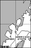
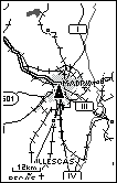
Rural Road Views from Garmin R&R and Lowrance CityStreets, Compared

________
     R&R                    GM100                      R&R                GM100                        R&R                 GM-100

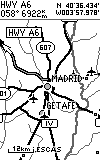
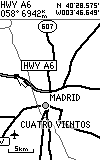
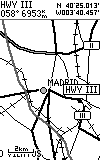
The above rural map views compare the quality of the maps from the R&R and the GM100.  Generally,  both maps include the same rural roads and BOTH are quite complete.  The R&R maps are a bit newer (at least in the Atlanta area).  For instance,  in the above maps,  the R&R MapSource maps show AC Smith Road (correct name) whereas the GM100 calls the same road Silver City Road (name before 1993).    In some instances,  R&R shows a road not on GM-100 and in other instances,  the reverse is true so neither map is perfect and if history is a true guide,  accuracy in both will vary from area to area.

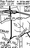
Other Typical Comparison Views
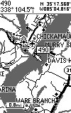
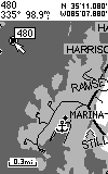
Inland (navigable) Lake Chickamauga (Chattanooga, Tennessee)
Showing Mile Marker, Marina, and State Park Icons:
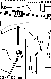
*
             R&R                                  GM100                                  R&R                             GM-100

The below are example comparisons of the Garmin WorldMap (with nav aids) to the Lowrance WorldMap

 
        Garmin              Lowrance                   Garmin              Lowrance
===================================================================================
ADDITIONAL WORLD MAPS ARE SHOWN BELOW

 NOTE: There is a 2.5:1 ratio (below) between the mileage scale of the GM100 and the km scale of the Garmin:
Lowrance GM100 WorldMap CDROM (Uploadable Map)

------------------------------------------------------------------------------------------------------------
Garmin G-III International ( Internal BASE) Map

-------------------------------------------------------------------------------------------------------------------------
Garmin G-III+  MapSource World Map (Madrid Area)


-----------------------------------------------------------------------------------------------------------------------

 See additional examples of WorldMap and Nautical Nav Aids screens HERE

Joe and Jack