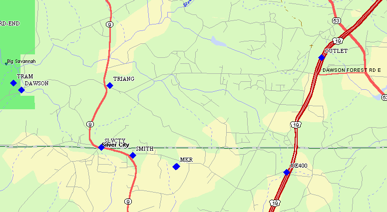
Route Created Without
Special Instructions
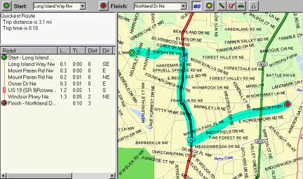
Route Created With Stop
(No. 1) Inserted
Addendum: Street Atlas 8 is an updated version of SA7. In some parts of the country the accuracy has improved such that creating routes and uploading them the the Garmin StreetPilot results in much better "rubberbanding" of the route legs to the streets and better displayed directions. However, in some parts of the country, the accuracy is much worse with some streets displaced far from their original correct positions. Compatibility with Magellan Garmin, and Lowrance receivers apparently does not require any "fixes" to be downloaded from Delorme. G7ToWin has also been upgraded to work with SA8. This graphic illistrates the mixed quality of the current version (HERE).
Delorme follows up its SA6 with another quality GPS integrated mapping program, Street Atlas 7.0 (SA7). SA7 has many new enhancements which add substantial utility to the program. Typical screen image (HERE) shows downloaded waypoints (blue rectangles) with names from a GPS. The following include (but are not a full list) of features:
* Address-to-Address automatic routing,
by street and city name. No zip code needed.
* GPS Voice Navigation directions
(Louder, clearer audio than in SA6. Still a bit weak in a normal
automobile).
* Improved GPS Interface with Garmin
GPS receivers (Works with latest Garmin GPS HOST mode).
* Sunrise/Sunset and Moonrise
Moonset calculator (added via upcoming Delorme update).
* Support for Lowrance and Magellan
tracking without the need to download "protocol patches"
* Palm Pilot PDA and WinCE
device support
* Points of Interest are back and
improved (over 3 million POI included).
* Maps have substantial updates both
in coverage and correction of errors (Don't expect perfection.).
* Includes accessory Solus 1.5 which
allows map uploading to PDA and WinCE units.
* Attractive street price of around
$45 or less, with an upgrade price of $25
* One way roads identified in major
cities
* Draw circles or polygons on map
and compute their area
* Display zip code and county boundaries.
* Upload/Download waypoints, tracks,
routes from Garmin, and some Magellan and Lowrance receivers
Our most important qualifications for a highway mapping program are: Good maps and automatic Address-to-Address routing directions. Street Atlas map programs from Delorme have had this feature for a long time. While SA5 and SA6 worked fairly well (most) of the time, we noticed that fairly often it would take some pretty unusual routes. For all of the routes we have tried with Street Atlas 7, these quirks are gone. In testing automated routing for perhaps 50 different journeys, we found all of the automated routing "acceptable". In many cases, the routes selected automatically were the same as we would have personally picked. In all other cases, we judged the route at least "acceptable". While there might be a slightly better route, a traveler unfamiliar with Atlanta would have always been quite pleased with the automatically selected route.
As to map accuracy. We find that in the Atlanta area, (which is the only area with which we are very familiar), we noted many additions, improvements, updates and two errors. Overall, we rate the map accuracy of SA7 (in our area) to be very good. There will always be room for improvement but for the uses SA7 is likely to be used for, the maps provide all of the information normally needed and at a very competitive price. We find that the maps appear to be lagging in time about 2 to 4 years as far as new street and housing development construction is concerned. The SA7 maps cover the entire USA and are not for just for a few states or metropolitan areas.
The automatic routing system functions for the entire USA. That is, the quickest route from 1 Beacon Street, MA. (02111) to 1 Market Street, San Francisco, CA (94111) is quickly calculated. This just as easily as a route across town. Most of the prior automated address-to-address routes that we have tried either did not function at all or at best did a poor job. (Note: We are NOT referring to town-to-town routes, but address-to-address routes. Routes in expensive mobile navigation systems like the Magellan Pathfinder and Alpine perform address to address routing and work very well indeed, but do not have the capability to route you beyond the extent of the CDROM area purchased.)
SA7 can produce "strip maps" or trip planning maps for extended travel. These maps have associated text directions and are very complete. We did notice that the default strip maps have a random direction for North and it is not consistent from map to map. This is OK perhaps, but for someone used to thinking in terms of "North UP", this can be a bit confusing. There is the capability in the travel package to print an overall "North Up" map, but the strip maps are still "Random Up".
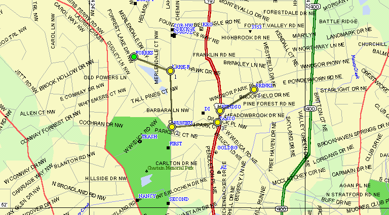
When a Route is calculated by SA7 on the PC, the route points are given specific logical names (such as NORTHR for "Northridge Road") which can be uploaded to Garmin receivers. When route generation is complete, the routepoints are connected by a solid pink line (on the PC screen) which is quite effective at showing the overall route generated. It is possible to add extra waypoints (vias or stops) and cause SA7 to vary it's route as needed. When the user is happy with the route generated, it can be stored and/or uploaded to the GPS. (Note: The default route name (Delorme Route) always uploads into the GPS's route #1 regardless of what you set the ROUTE NUMBER in SA7 set to. Be sure to always use a unique route name to avoid overwriting another route with the default route name.)
One VERY IMPORTANT and useful feature is the ability of SA7 to automatically generate a new route should the user deviate from the computer generated route. Thus, if you find you must make a detour for some purpose, SA7 will continuously generate new route options toward getting you most effectively to your original destination. How far you deviate from a specific route before a recalculation is done is user adjustable.
Route Created Without
Special Instructions
Route Created With Stop
(No. 1) Inserted
Software Compatibility:
SA7 has the ability to work well with Garmin GPS receivers including
those with Garmin's new HOST mode. SA7 generated routes do not 100%
"rubber band" to SP and SPCM roads as there are minor differences between
the positioning of SA7 roads and Mapsource/Metroguide roads. When
necessary, minor adjustment of a few intersection waypoints corrects
this problem and the desired "rubberbanding" occurs in SP/SPCM.
SA7 also will exchange data with Lowrance and the newer model Magellan
GPS receivers. With the original version of SA7, Joe
experienced some difficulty in "getting connected" to Garmin GPS receivers
whereas Jack's combination of computer and different Garmin receivers had
no problem with dual initialization being required.. New downloadable
drivers (beta test now, to be released soon) from Delorme have corrected
this (Joe's) problem completely for all of the Garmin receivers we
tested.
Waypoints with NAMES and stored tracks can be downloaded and displayed on SA7. However, routes downloaded to SA7 use the same symbol and do not show any lines connecting the routepoints. An example of how G7ToWin can distinguish between a mixture of downloaded waypoints and routepoints (with lines drawn between routepoints) is shown (HERE).
For GPS interface, we selected "Garmin/Garmin" and we found this worked for Navtalk, G-12Map, G-III+, and the new eSeries . It should work for all Garmin receivers with the new HOST protocol. Others will have to switch between NMEA and garmin/garmin. NMEA for tracking real-time and Garmin/Garmin for upload. Other GPS selections are "generic NMEA", Rockwell binary (Earthmate), Lowrance, Trimble, and Magellan. SA7 has a number of good search features. You can search by lon/lat, place name, phone number and address. New with SA7, a search for an address can be made either with a zip code or the city name.
Draw Object "Text Notes" and "Place Notes" (waypoints created by SA7) containing Lat/Long are uploaded with the first 5 or 6 note characters and shown in the Waypoint list. The first 16 note characters are shown in Comments when uploaded to the Garmin receivers that support Comments . Uploading "Map Notes" results in no recognizable names or comments in the Garmin receivers. Routes can also be uploaded to Garmin and Lowrance receivers and to later model Magellan receivers. (Consult Delorme or Magellan for specific model compatibility.) SA7 can also be used to download the first six characters of waypoints and routes plus tracks from most receivers.
Real time track width is a series of adjustable-size green arrows. We find this "OK", but would much prefer a "track log line" that did not continuously erase itself. (We realize from MapExpert of years ago that such a track log line presents repaint problems for Delorme when the trail gets long.) The real time tracks have a fairly short "trail" on the SA7 screen and for a full track of a journey it is still necessary to download the track from your GPS storage. The present trail arrows are satisfactory on the normal screen but almost disappear when the display is switched to "mobile mode". The Mobile mode makes the display much more readable in darkness, but I found the normal display quite satisfactory on my Dell 3500 computer day or night.
Automatic Pan, logging, tracking are supported. Points of Interest include restaurants, hotels, gas stations, etc. Radio Station Listings along your travel route are available also. Edit Roads allows you to specify roads one way/no left turn, etc. when they change (or are not properly noted).
Palm Pilot PDA is now supported in consort with a main computer. WinCE devices are also supported. (We have not tested this feature.) Solus software is required to use this feature. SA7 does not include Solus Pro 1.5. Rather, it includes Solus Basic 1.5. The difference is that Solus Basic allows users to upload one map and one route to a PDA. Solus Pro 1.5 allows multiple maps and routes to be sent to a PDA and is also GPS compatible. You will need to purchase Solus Pro 1.5 separately in order to use the GPS functionality with a PDA.
Map updates sent in for SA5/6 by the reviewers were incorporated into SA7 maps. (However, these updates are missing in SA8). We find the roads fairly complete and all of the local residential streets we checked were included. (One small group of streets has a major error not in SA6.) Others have reported missing streets, so perfect maps still escape us. Report every map error you find to data@delorme.com and you will help all of us. The map format is standard, but the addition of features such as one way streets, no turn intersections, freeway interchange numbers, and detailing freeway interchanges are enhancements. A most welcome addition is an automatic address route planner.
The "Introductory guide" booklet is quite abbreviated indeed. However, installation of SA7 went well on both Windows 95 and 98 systems, and unlike prior versions, all of the necessary files were included on the install disk. The only software operational problem we saw was the difficulty of "connecting" with the Garmin HOST mode. This problem was corrected with a new driver patch from Delorme and no further problems were observed. An "Extractor" feature permits a user to copy specific areas from the CDROM to the hard drive so that having a CDROM drive in a computer is not necessary. We were not able to get the extractor function to work on any of the three computers we tried it on. We worked with Delorme on this and it appears that our disk set is defective in this area.
Once loaded, we found SA7 to be quite intuitive to use in "most" cases. A rule we would recommend is that if you can't find the function you want, point with the mouse and push the RIGHT mouse button. Many functions such as "point at the map and put a start/stop route point" and "edit map" are not available any other way. Most of the things we wondered about were included in the help files. We did not observe any software "crash/lockup" problems with SA7.
SA7 requires a 486DX-66 or greater, 16 megs RAM, 35mbytes HD space, Windows 95, 98 or NT, SVGA, 256 colors, mouse, CDROM, Windows compatible printer. No W3.1 or MAC versions are mentioned. GPS compatibility listed is Earthmate, G-12, G-12Map, G-III , G-III PLUS, NavTalk, G-II(&+), G45, G30, Magellan, Rockwell binary (Earthmate), Trimble ScoutMaster, Lowrance/Eagle, or "fully compatible NMEA receiver". Basically, SA7 provides a VERY complete (but not absolutely exhaustive) road map of the entire USA. Maps are substantially improved over SA6 and road maps appear to be up to date within about 2 to 4 years. As will ALL mapping software, you will find some errors. However, SA7 accuracy and "up-to-dateness" and completeness is among the best available. At the price, we rate it a "best buy"
SA7 is provided on two CDROM disks, one is used for installation and the other for normal operation.
NOW if you get lost, "who's to blame?!".
Please send corrections/comments to:
Jack Yeazel -or-
Joe
Mehaffey