Text by Jack Yeazel and Michael Jones
(Add Receiver Accuracy: 18 Oct. 2004)
Return to GPS General Information Home Page
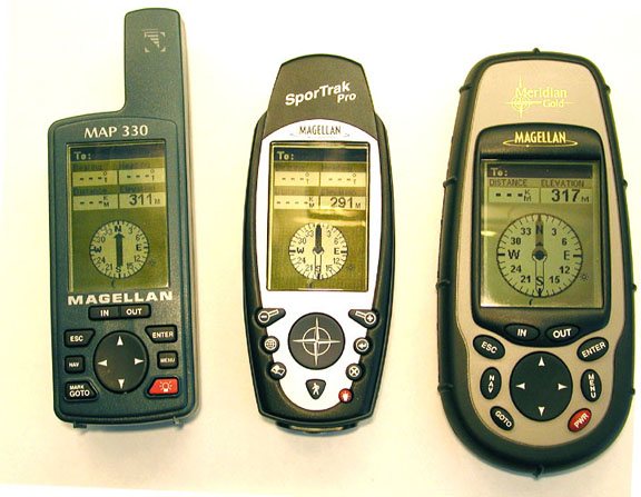
Comparison of Units (both with backlight ON)
The most noticeable characteristic is that the screen is exceptionally clear and bright with (16) colors -especially with the backlight ON (which also backlights the keys). The default ON is with the screen backlighted to maximum. Pressing (and holding) the power button decreases the backlight to half and then to OFF. The backlight can be set to turn off from 30 seconds to ten minutes. Any time a key is pressed, the light comes on for the selected time and brightness. This procedure enables the screens to be read easily in any lighting condition. The Color screen is much more visible than the Magellan ColorMap and has about 50% more (Pixels) than the Pro. The answer to the question, "What does the wrist strap attach to?", is "Thread it through a hole for one of the case screws".
Battery:
The Color uses two AA size batteries,
and the manual says it has a 14-hour capacity with the backlight off.
To replace the batteries, one must first remove the data cable, if attached,
but not with the Pro. At first glance the large battery door looks
"fragile" and not waterproof. However, there is a plastic ridge on
the battery cover which presses down on a neoprene gasket inside the unit.
This probably works very well. The battery compartment closure
is a "snap-on" (and not a screw-in as with the Pro), so care should be
taken not to lose it. The current
drain was measured at 120ma (with
the backlight off) indicating a battery life of 15 hours.
OPERATING SYSTEM:
A data cable is supplied with the unit
for uploading upgrades and MapSend maps. We had no problem uploading
a Streets and Destinations map at 115,200 baud. And had no problem
uploading 400-plus waypoints to the unit from G7ToWin
at
9600 baud. For best data transfer, NMEA should be turned off.
As with all Magellan units, waypoints cannot be selected alphabetically except by scrolling through up to half the waypoints, which can be very tedious. But, unlike the Garmins that sort only a limited number of Nearest waypoints, the Magellans sort ALL the waypoints by the distance from present position or the cursor. You can find waypoints in Find By, Nearest to: Position, Cities, Cursor, Address, or Other (which includes quite a few more).
The operating system seems to be essentially the same as the Meridian Platinum (Ver. 4.02). Both primary and secondary coordinate systems can be shown simultaneously on the position page by toggling it left and right. A unique feature of the Magellans is the inclusion of a built-in Help File. Audible alarms are provided for Arrival, Anchor, XTE, and GPS fix.
Satellite Screen:
If the compass is activated, this screen
orients itself to north automatically, i.e. it is free floating and orients
itself (even if you are stationary). On this screen are shown the
visible GPS satellites (white-on-black when locked on) and a corresponding
"W" for the geosynchronous WAAS (or EGNOS) satellites.
COMPASS:
The 3-axis compass is a major plus for
Magellan over Garmin. The compass retains its accuracy with any tilt
angle. With the Garmin
GPSmap 76S, you have to hold the unit
vertically for best reception but horizontally to read the compass.
The map and compass can be oriented to Magnetic or True North, and the
compass will read out in Degrees or Mils. To switch off the compass
(for use in an automobile, for example), use MENU, Setup, Compass Orient,
GPS Course. The compass will then show direction of travel.
Garmin units accomplish this with just a push of a button.
The compass is operating any time heading is being displayed. So, while on either of the two compass screens or on the Map Screen (the position cursor is pointing to your heading), the compass is running. On the other navigation screens, the compass is off unless Heading is selected for one of the data fields. In order to turn the compass (completely) off, go to Setup, and with the Compass Orient option, change it to GPS Course. To restore, select "Magnetic North".
Compass Accuracy:
After calibrating with NiMH batteries
and compasses set to true north; testing over a NESW grid shows:
Magellan SporTrak Color: N 002°, E 086°,
S 184°, W 280° TOTAL ERROR=20°, AVERAGE=5.00°
Garmin GPSmap 76S:
N 359°, E 089°, S 181°, W 272° TOTAL ERROR=5°,
AVERAGE=1.25°
Calibrating the Compass:
The electronic compass requires that it
is recalibrated every time the batteries are changed. Failure to
calibrate the compass could result in errors of 20° or more to the
displayed heading. Calibration is very simple and doesn't take more
than a couple of minutes. The calibration is similar to the Garmin
calibration, but adds one more step to accommodate the 3-axis capability
of this design. As usual, it's very important that there are no metallic
objects near the Color during this calibration.
1. Lay the unit down
face up on any LEVEL, non-metal surface.
2. Press the MENU button,
highlight Setup, and press ENTER .
3. Highlight Compass
Calibrate and press ENTER.
4. Using the on-screen
bubble level, set the Color on a level, non-metallic surface.
5. The Color will provide
the instructions on rotating the receiver.
6. Continue rotating
the unit until it beeps. (This will be slightly more than one complete
rotation.)
7. After the beep,
turn the unit FACE down. Very soon it will beep again. When
this happens, calibrating the compass is finished.
COMPASS SCREEN:
COG (Course Over Ground) Pointer and
Icon:
This unique pointer, not available in
the Garmin units, is a useful new feature. When using the Compass
Screen to steer to a destination, the goal is to align the destination
Pointer and the COG Pointer together. When both of these pointers
are lined up, regardless of your heading, you are moving in a straight
line to your destination. This is a welcome feature for sailing enthusiasts.
Note: With no GOTO or Route selected, the Destination Icon disappears. With the compass off, the COG pointer and icon are always at the top of the screen (direction of travel -which by definition is always COG). If the compass is active, the Pointer points to the numeric COG, and here it is important that the unit be pointed 'forward'.
RECEIVER
ACCURACY and SENSITIVITY:
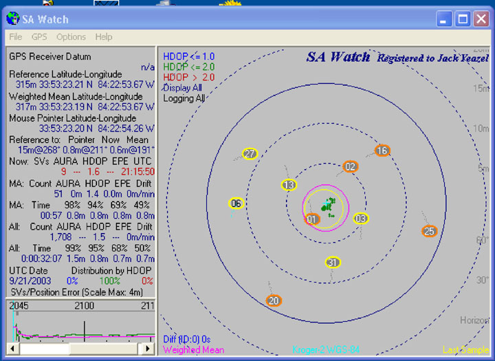
Using a moderate tree-cover test site,
we ran 30-minute test runs with
SA Watch comparing the GPSmap76C to the Magellan SporTrak Color (HERE).
The 76C seemed quite "erratic". 95% of the 76C errors were less than
9.7 meters, where the SporTrak Color were less than 1.6 meters.
All later Magellan units have a feature called Automatic Position Averaging and results in the low drift rates and less scattering we recorded. This feature can't be turned off. According to the Position Page, automatic averaging kicks in when the velocity is less than about 1 km per hour.
The Sportrak Color appears to repeat the SporTrack Pro's good accuracy with WAAS enabled. In a test over a GPS reference point with SA Watch (HERE), the Color was able to achieve an accuracy of 0.8m 95% of a 32-minute test period made in the open. The average error was 0.6m@191°. The maximum error after breaking the position-averaging lock was 1.5m.
Sun and Moon:
This screen also contains a Sun and Moon
icon. With the compass turned on, aligning these icons with either
the visible sun or moon can verify the compass accuracy. With the
compass turned off, North can be determined while standing still.
MAPS:
We had MapSend Streets and Destinations
4.0, Topo USA 3.0, and WorldWide BaseMap 1.00 to work with.
NOTE: The
new MapSend
DirectRoute maps will provide more accurate maps than those mentioned
below plus provide automatic routing.
MapSend Streets and
Destinations:
This map allows map transfer at 115,200
baud, and four disconnected regions can be uploaded.
MapSend
Topo USA:
This map only allows map transfer at 19,200
baud, and the limit is also four regions.
The map contains both topographic information
and what looks to be the MapSend Streets USA street detail.
MapSend
WorldWide BaseMap (with topo information):
Only one region of this map can be uploaded
at a time. It is possible to upload both street information (e.g.
as in MapSend Streets USA) and the WorldWide BaseMap. The maps are
not displayed simultaneously, but if you zoom out far enough, the WorldWide
BaseMap switches from the detailed map (if loaded) to the new WorldWide
BaseMap (if loaded). The built-in BaseMap can also be displayed if
the WorldWide map is disabled.
The map-screen 'Scale' is 1/4th the width. All of the many map details can be turned ON or OFF. Users should not panic when they get to the section of the manual on using the Color with MapSend. It tells you that you need an SD card installed. We suspect this is a cut and paste error from one of the other manuals (Meridian perhaps?). Magellan confirmed that this was an error.
Automatic Map Switching:
The unit switches off the street detail
from 350m to 700m zoom and then switches to the WorldWide BaseMap
map at 1.4km zoom. At 2.5km, panning the cursor will reveal the closest
waypoint to the cursor whether the waypoints are displayed or not -up to
some unknown distance from the waypoints. Past this distance, the
cursor reveals the elevation.
Map Detail settings have no effect on the topo map except at 'Highest' where the street map always takes over at 2.5km zoom. From the smallest to the largest region upload, the file was always about 1MB in size. Apparently the first 800K or so is the program to generate contour lines from the Digital Elevation Model (DEM) database.
Map
Utilities:
Map Utilities (also present in the Pro
4.04, but not the Platinum) is accessed from the first MENU selection.
It has two selections:
Change Map and Delete File.
Change Map has selections
of: BaseMap and Detail Map
Under BaseMan: Default Map or BaseMap.mgn can be selected
Under Detail Map: Detail Map Off or Secndmap.dat can be selected
Under Delete File:
BaseMap.mgn or Secondmap.dat can be deleted
Normal operation would be with: BaseMap/BaseMap
and DetailMap/Second-Map
NOTE: One
must remember to "Save" these settings, before they will take effect.
The question, 'can you upload both maps of the US and Canada to the unit' has not been answered. You could with a Garmin. We have no Canadian maps to evaluate down 'here'. The BaseMaps of the Pro and Color appear to be the same.
Map
Screen:
The display options in the Color include:
Orientation: North
Up, Magnetic HDG UP, Course Up, or Track Up.
Detail: Highest, High, Medium,
Low, or Lowest.
TrackMode: Off, Auto, Auto
Detailed, 2.0km, 1.0km, 0.5km, 0.2km, 0.1km, 0.05km, and 0.01km (10m).
Primary Usage: Land or Marine
(water/land is either light or dark to make the tracklog more visible).
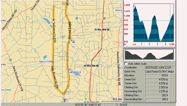
MapSend Profiles and the
Odometer:
The Color displays a resetable odometer
on the Speedometer Screen (below). MapSend maps can also display
a downloaded track's distance traveled as shown in Track,
Profile. Moving
the cursor over the profile reveals track data at any selected position
including Linear and Terrain distances. A circle icon also shows
the position on the tracklog.
We understand that the odometer distance is calculated from speed over time, thus when the unit loses lock, distance is not recorded and will be less than the profile distance which is based on the track length. However, the color will sound an audible alarm (if selected from Menu, Alarms/Msg.) when lock is lost as do the Garmins. Another feature of MapSend is that from the Track 'Control Center', the tracklog can be 'played back' at from 1x to 50x speeds.
BUILT-IN DATA:
The SporTrak Color comes
standard with a base map, NA-Marine 1.08 consisting
of Cities, Highways & Major Roads, Waterways, Airports, Parks, Fixed
Navaids, Buoys, Lights, Fog Signals, Radar/Radio, but not
Lighthouses, Marinas, or Obstructions as with the Pro.
MEMORY:
The Color and Pro memory includes 9MB
of base map and 23MB for uploadable maps. This compares to the 330's
8MB of base map and 8MB of uploadable map memory. The SporTrak
Map has a 2MB base map and 4MB for uploadable maps.
USER DATABASE:
This database contains the recorded waypoints,
and can be sorted by Near Position, Alphabetical, or Near City. To
find a waypoint in the alphabetical list, one must scroll through up to
half the waypoint list which can take some time. There is no "spell
matrix" as with the City list. Waypoints have an 8-character limit,
but can be either upper or lower case plus punctuation. The Color
has a capacity of 500 waypoints, and up to 200 waypoints can also contain
"Messages" of up to 30 characters. There are 42 waypoint icons to
choose from.

NAV SCREENS:
These screens can be selected to display
or not display. Un-needed Garmin Nav screens cannot be controlled
this way.
WAAS:
Before WAAS corrections are received,
the Position Page message is "Averaging". With WAAS corrections,
the display message is "WAAS Avg.", and while moving, the message
is "WAAS". One can reset the averaging by 'moving the unit around'
In the Atlanta area, all Magellans we have reviewed can receive corrections from the AOR-East geosynchronous European EGNOS satellite and the AOR-West WAAS satellite. The units are permanently in the WAAS mode which can't (easily) be switched off. This will be a problem for users far outside the WAAS and EGNOS correction areas. For example, users in Australia have reported significant position errors introduced by receiving the POR satellite's WAAS corrections.
For those that MUST deactivate WAAS, perform the following keystrokes (not approved by Magellan and may lock up the receiver): MENU, Right, Left, Right, Left. A "00" box appears. Rocker up to "03", Enter. Another Enter will deactivate WAAS. Esc, Esc, and then power off. (This is important; other keystrokes may lock up the unit). To turn WAAS back ON, rocker back up to "03" and press Enter.
TRACKLOG, BACKTRACK, and
ROUTES:
The maximum number of trackpoints is 2,000.
As with all Magellans reviewed, the tracklog connects points from separate
logs no matter how far apart they are or if the receiver has been turned
off between tracks. The Magellan Map-330, Meridian Gold, Pro, and
Color have the best backtrack in the business, because each and every trackpoint
is used in the Backtrack. This Backtrack won't run you aground, as
with the Garmins, because it does not cut corners when converting the tracklog
to a backtrack. The tracklog detail has ten selections; Off, Auto,
Auto Detailed, 2.0km, 1.0km, 0.5km, 0.2km, 0.1km, 0.05km, and 0.01km (10m).
NOTE: Color units automatically
"name" a Backtrack route:
"T_track-number_P_beginning-point-number,
T_track-number_P_ending-point-number".
One drawback to Magellan tracks is that
they are all comnnected together -even if they're not. An example
of this problem and a fix can be found (HERE).
The Color has a capacity of 20 routes with up to 30 routepoints. A Trackback can be converted into a route with a maximum of 30 routepoints. This will allow you to convert a track to a route and then begin another track (after you clear the current track file). So, you can, in effect, have many tracks saved, just in a 30 leg route form. You also can use all of the route editing features after the conversion is complete.
ROAD and COMPASS SCREENS:
The Road Screen provides a 3-D image of
the Backtrack route, four selectable data boxes, and a compass ribbon.
The road display is 'zoomable'. On the compass ribbon are four undocumented
(as far as we can determine) symbols. There is an arrow which
points to the direction you need to turn to stay on the Backtrack or Route.
Then when you are heading in approximately the correct direction, a 'diamond'
symbol appears which is the bearing to the next routepoint. Following
the diamond makes traversing a backtrack or route much easier.
The other two symbols are the sun and moon bearing. The sun and moon-bearing icons on the compass screen are a definite assist in orienting one's self while standing still with the compass turned off.
SOFTWARE COMPATIBILITY:
Any of the MapSend maps can exchange and
display data from the Magellan receivers. G7ToWin
has recently been upgraded to archive and edit data from Magellan receivers,
including the Color, and show it on Street Atlas maps. Ozi
Explorer can also show the Magellan data on scanned and DRG maps.
Street Atlas 8/9 can download waypoints, routes, and tracks from the Color
and also upload waypoints. When downloading routes, SA first downloads
all the waypoints (also required by G7ToWin) -and then the routes.
However, only with G7ToWin will the route legs on SA be connected by lines.
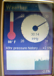
BAROMETER:
In addition to the electronic compass,
the Color provides a mini-weather station with temperature and barometer
information.
 ..........
Accessing the Weather
Screen:
From any screen press MENU, Weather,
and press ENTER. The Weather Screen is displayed with the current
temperature and barometer information. Temperature and barometric
information are displayed in a familiar and easy to read format.
The bottom of the display is a graphic of the barometric readings taken
over the last 48 hours. (The Color will take barometric readings
anytime the unit is active.)
A new bar indicating the barometric pressure is added to the graph once every 15 minutes. If during the course of an hour it has taken two readings, it fills in the gap between the readings. If, however, the receiver has been turned off, or it does do not have enough satellites to compute altitude (four satellites are needed for altitude computations), and only one reading or less has been taken in the course of the last hour, there will be gaps in the chart.
Calibrating the Temperature
and Barometer:
This is not a requirement for using the
temperature and barometer readings, it simply makes the readings a little
more accurate.
1. From the Weather
Screen press MENU, Calibrate, and press ENTER.
2. Enter the corrected
temperature and barometric pressure values, and press ENTER.
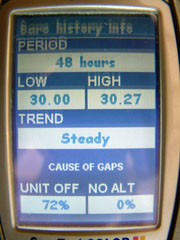
Accessing Barometer History:
You can also view the barometer history
displayed in the barometer graph in a textual format. This screen
will also provide the low and high barometer readings for the last 48 hours
as well as the reason for the gaps in the chart. From the Weather
Screen press MENU, Baro history info, and press ENTER.
The accuracy of the barometer is hard to discern. Tests made in cool weather show that the barometer readings vary considerably with temperature changes. For example the barometer was calibrated to the weather bureau at 66°F, but when taken outside to 43°F, the reading dropped 0.10"Hg. Then when warmed to 71°F, the reading increased 0.21"Hg from that point. Several temperature cycles (all compared to the weather bureau) indicated that the barometer readings drop with temperature decreases and increase with temperature rises. As compared to our measurements of Garmin's 76S barometer accuracy of 0.02" Hg, the Color barometer does not appear to indicate a useful measurement except after calibration while stationary.
The relationship of the barometer to the GPS altitude isn't known at this time. However, the barometer readings don't increase with altitude decreases (and vice versa) as the Garmin Vista (incorrectly) does. The manual says the weather summary is for 24 hours, but the unit records a summary of 48 hours. As of this writing, we don't know of any way to change it to 24 hours, which seems to be a more practical time period. The manual also says that the Color will take pressure readings 'Anytime the Compass is active'. This probably should be, 'Anytime the unit is active'.
Limitations on Temperature Readings:
Since the temperature sensor for the Color
is inside the receiver, it is trying to read the temperature of the receiver
and not the ambient temperature. There has been compensation made
to the temperature readings in order to accurately represent the ambient
temperature. Temperature readings in the unit seem to be quite accurate.
CONCLUSION:
This receiver is well worth the money.
Good sensitivity, good accuracy, small size but very visible screen, good
selection of maps, and the best electronic compass in a hand-held.