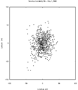
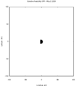
The images compare the accuracy of GPS with and without selective availability (SA). Each plot shows the positional scatter of 6.5 hours of data (0730 to 1400 UTC) taken at one of the Continuously Operating Reference Stations (CORS) operated by the U.S. Coast Guard at Hartsville, Tennessee. On May 2, 2000, SA was no longer present. The plots show that SA causes 95% of the points to fall within a radius of 44.2m. Without SA, 95% of the points fall within a radius of 4.1m.
Fine Print: Data taken at the Hartsville National CORS station, National
Geodetic Survey, NOAA. Data with SA were taken from 0730 to 1400 UTC on
May 1, 2000. Data without SA were taken from 0730 to 1400 UTC on May 2,
2000.
Both data sets were taken at 30 second intervals. Instrumentation was
an Ashtech Z-12 receiver. GPS data were dual-frequency pseudorange (both
L1 and L2) incorporating ionospheric correction. Data were processed in
accordance with the GPS Interface Control Document ICD-GPS-200C, using
the broadcast orbit parameters in the World Geodetic System WGS 84 (G873)
reference system.