Magellan's Topo 3D USA Ver. 1.00 Maps
For questions about this product, log onto the GPSInformation.net
FORUM
Return
to home page * Text by jack
yeazel and allory deiss (1 June
2005)
(3 Mar. 2007 -Add
additional Information about the copy protection on the new 3D USA maps)
HARDWARE UPGRADE:
The following Magellan units are capable of uploading these maps:
Meridian Color, Meridian Gold, Meridian Platinum, Meridian Marine,
SporTrak Color, SporTrak Pro, SporTrak Pro Marine, and the 400, 500, and
600 eXplorist models.
We upgraded our Platinum to Ver. 5.35 without incident, but we did
have to remove the batteries to turn the unit off -as suggested.
Allory also evaluated the program with his SporTrak Pro. The fastest
upgrade allowable is at 19,200 baud.
GENERAL:
As with the Magellan MapSend Topo USA maps, Topo 3D USA maps, about
$90, check prices (HERE),
allow Magellan GPS units to display a constantly updated view of the contours
of surrounding hills and valleys. The units draw topo contours on-the-fly,
adjusted to the zoom level at which you view the map.
However, with these new 3D maps, the resolution is increased threefold
over the older topo maps, requiring more CD and GPS memory space.
This map now displays terrain detail approximately equal to Garmin's USA
Topo map. One could dispense with all Magellan's previous
USA maps (except the auto-routing ones) with this 3D map. (The contour
lines can be turned off if desired leaving the new NavTeq street maps uncluttered).
Moving the GPS cursor causes the unit to read out the ground elevation
at the cursor and its bearing and distance. A constant readout of
the current GPS elevation can be displayed in one of the map data boxes.
The 3D view is available on the PC only. ( Data disk No. 3 must be in the
PC in order to run the map program, and a backup disk will not suffice.)
MAP UPLOAD:
Move throughout the map on your PC and define regions to upload
to the SD card or built-in memory of your GPS. Regions as large as
240 MB can be transferred to an SD card in one shot*. For example
the entire state of Washington will fit on a 64MB SD card. The uploaded
map includes detailed topography, waterways, POIs and NavTeq streets by
default or you may customize the level of detail to suit your needs. You
can define as many regions as you wish and change the map region in your
GPS as you please. One can choose 115,200 baud when uploading maps
via the serial cable.
* It is recommended to use an optional SD card reader/writer for
map uploads over 64 MB.
COPY
PROTECTION:
MapSend Topo 3D USA 1.00 (which comes on CD) is licensed for use
with one Magellan GPS receiver, although the program allows up to three
changes to the original serial number entry. However, the new Topo
3D USA v1.5 (on DVD) will allow uploading maps to only one receiver: the
program requires an unlock code associated with the GPS serial number.
The program and its unlock code can be loaded on multiple computers for
use with the same GPS. However, if you have a SECOND receiver bundled
with the new Topo 3D USA requiring a second unlock code, you will need
a second PC Computer to install the maps in order to upload them to the
second unit--a given computer can apparently handle only a single GPS serial
number.
MAP DATABASE:
All MapSend Topo products use a grid of equally spaced horizontal
points, each point having an elevation value, to model the earth's surface.
This grid drives the drawing of contour lines on the screen at various
zoom levels and it enables Magellan GPS receivers to perform elevation
profiling on roads and tracks. MapSend Topo 3D USA uses the United
States Geological Survey (USGS) National Elevation Data 30 meter elevation
grid, the most detailed topo elevation dataset available for the USA.
MapSend Topo 3D USA brings this detailed topo data together into
one seamless map for the entire continental U.S. plus Hawaii. The
package also includes extensive, searchable USGS points of interest such
as mountain summits, valleys, springs and much more.
When going from the Topo USA to the Topo 3D USA maps, Magellan has
switched from TIGER (Census Bureau) street maps to NavTeq street maps which
are much more accurate. You will notice below that there are also
more vectors per curve in the new map. The water detail, however,
doesn't appear to be as accurate as with the Garmin topo maps.
ELEVATION PROFILING:
Is quite useful for hiking, mountain biking and hunting. MapSend
3D Topo enables profiling the elevation change along roads, trails, routes
and tracks on your GPS receiver or PC. Put the cursor on a trail
or road, Enter, and view the profile. You can skip the path that's
too steep or go for it, if that's your style.
NOTE: The folowing only applies to the
Meridian and Sportrak models. The eXplorist units show some profiles,
but not those described below.
ACTIVE PROFILES:
Activating a Vertical Profile in the GPS unit is a little tricky.
Menu, Map Setup, Orientation, must be either Track Up or Magnetic Heading
up. Magnetic Heading Up (on units with a compass) allows one to survey
the surrounding topography while standing still.
VERTICAL PROFILES:
Menu, Vertical Profile, has three selections: Track History, Path
Check, and Route.
Track History shows the profile of the recorded track which
you can scroll left and right to display the track's recorded elevations.
Path Check will show a proposed path profile with the following
procedure: Pan and click along the proposed path with GOTO.
Pressing Enter will show the profile which you can scroll left and right
to see the elevations.
Route shows the profile of a selected route which you can
also scroll left and right to see the elevations. The easiest way
to develop a route is to create it on the PC (which automatically creates
the waypoint names) and upload it.
DYNAMIC PROFILES:
From the map page, press Menu, Select Map Info, then select Horizontal
Profile or Terrain Project. The Horizontal Profile is the terrain
left and right, and the Terrain Project is the profile of the path ahead.
The current GPS altitude is displayed in the terrain profile on
the bottom of the screen at a small black triangle representing your position
on the profile.
THE 3D FEATURE on a PC:
On your PC, click the 3D button for a 3D view of the area.
Without the GPS unit connected, by using the arrow keys, you can turn the
map left and right, and move forward and back. Zoom in or out
and set the elevation magnifying factor. See an example below.
To activate real-time tracking, select GPS Log and Start.
Driving with a laptop connected to a Magellan receiver's NMEA serial
output creates an amazing (and even eerie!) 3D picture of the terrain ahead.
The map rotates and tilts automatically as you drive along. The program
display appears to keep a constant elevation above the terrain as you move
over the map's hills and valleys.
TRACKS:
Can be displayed to show different colors depending on speed.
SEARCH:
There are three "searches": by Address, Name, or Coordinates.
In searching by Name, one is directed to choose a state. Then choose
Points Of Interest (POI), Cities, Airports, Roads, Waterways, or Parks.
The POI "Category" defaults to Trails.com (interesting sites including
many trailheads.) The list is very extensive. One can "scroll
down" or type in a "search string" to speed up the process. If Trails.com
isn't selected, there is a long list of other categories of POI to choose
from.
POIs:
Magellan provides three complete integrated sets of searchable points
of interest.
NAVTEQ points of interest include hotels, restaurants, ski areas,
marinas and much more. Most NavTeq points of interest include address and
phone numbers, so you can call ahead for information and reservations.
U.S. Geological Survey Locate natural sites like Mount Shasta,
Old Faithful, Cumberland Gap and many more.
TRAILS.COM includes over 30,000 outdoor destinations from 1000 well-known
guidebooks for activities including hiking, camping, fly fishing, paddling,
mountain biking, cross country skiing and more. Click the link in
the POI detail and MapSend will take you to the Trails.com website, where
you will see additional information for each area.
Click on the link to a trailhead point of interest icon (requires
scrolling down one item) to get valuable information to help prepare for
your hike ahead of time. For example, find out the mileage of the
hike, the degree of difficulty of the hike, about how long it will take,
if you need a pass from the Forest Service and any interesting things to
look for along the way.
Subscribe to Trails.com and get even more value. Download and
print the chapters from the guidebooks. Use the Trail Finder to explore
other recreation opportunities. Save your favorite trails, view and
print sections of USGS quad maps and more. Trails.com subscribers
can also download guidebook trail chapters.
NOTE: These databases can also be searched on the unit itself
in the areas of the uploaded maps.
Comparison of Magellan DEM Contour Line Renditions
with Garmin USA Topo and USAPhotoMaps
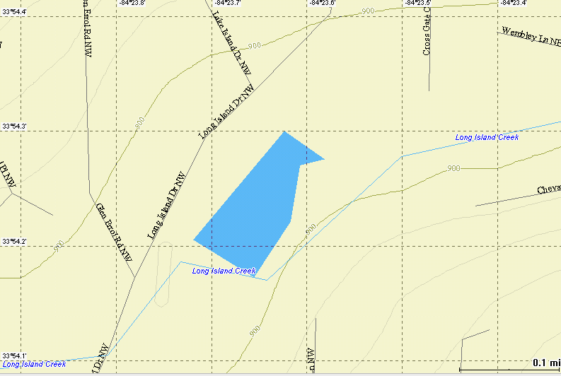
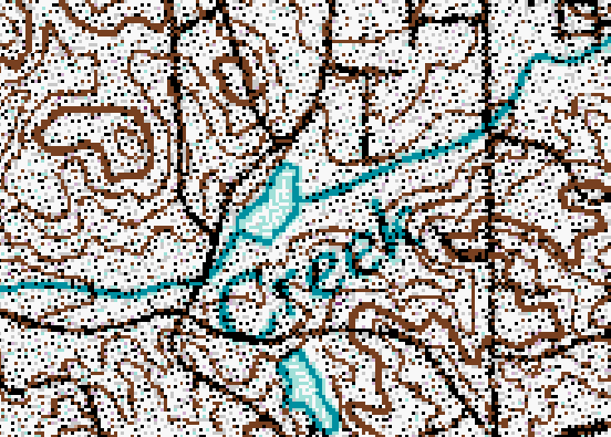
Magellan MapSend Topo USA Map Using
90m x 90m Cells
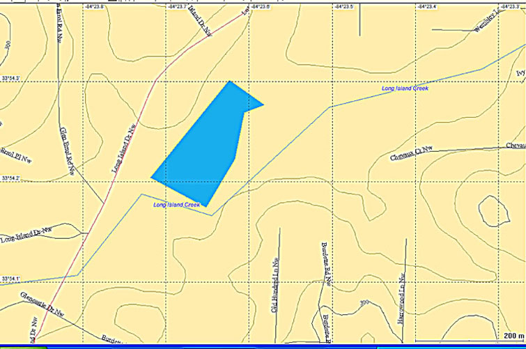
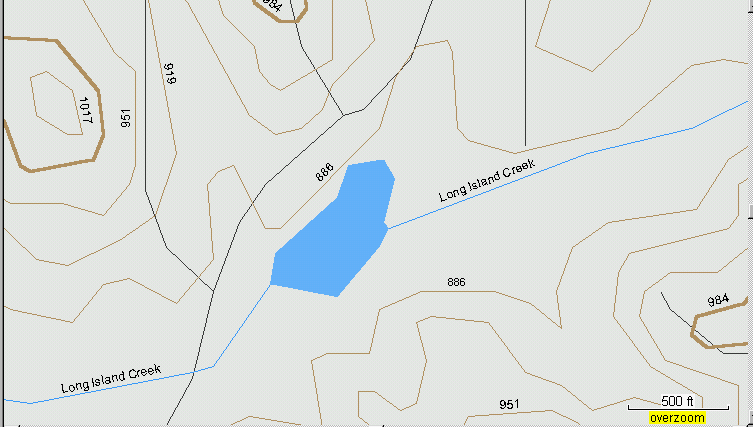
Magellan MapSend Topo 3-D Map
Using 30m x 30m Cells
These maps have considerable more detail than the Topo USA maps.
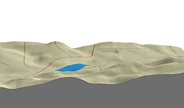
Magellan's 3-D Display of the Scene
Looks Pretty Realistic!
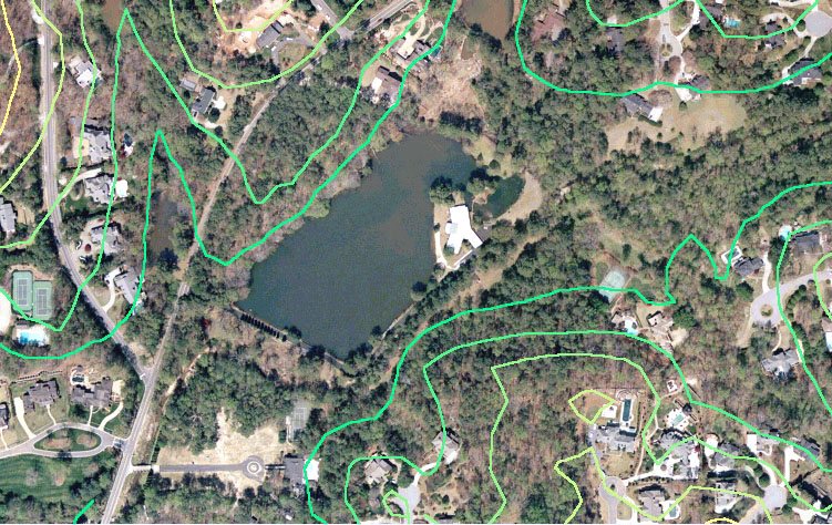
USAPhotoMaps
Color Aerial Photo uses 30m x 30m cells from the same database.
Garmin USA Topo Map from the USGS 1:100,000
topo maps
USGS 1:100,000 Topo Map from which
the Garmin maps are Derived
Jack
Yeazel