Text by Jack Yeazel
(Add indormation about DirectRoute Maps: 25 May 2004)
Return to GPS General Information Home Page
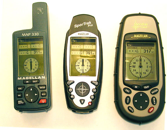
Comparison of Sizes
Built-in Data:
The SporTrak Pro comes standard
with a base map consisting of cities, highways & major roads,
waterways, airports, parks,
fixed navaids, buoys, lighthouses, marinas, and obstructions. The
SporTrak Map comes standard with a base map consisting of cities, highways,
airports, waterways, and parks. The SporTrak
Map base map is the same as the Meridian GPS base map.
POI Database:
The 330 contains Cities, Highways, Airports,
Waterways, and Parks. The Pro has these and adds Fixed Navaids, Buoys,
Lighthouses, Marinas, and Obstructions.
Memory:
The Pro memory includes 9MB of base map
and 18MB for uploadable maps. This compares to the 330's 8MB of base
map and 8MB of uploadable map memory. The SporTrak
Map has a 2MB base map and 4MB for uploadable maps.
Uploadable Maps and Databases:
NOTE: The
new MapSend
DirectRoute maps will provide more accurate maps plus provide automatic
routing. The 330 (which has been loaded with MapSend Streets USA)
has
a sub menu, "Map_330" which contains, Address, Streets-Roads, Waterways,
and Parks. The Pro (which has been loaded with the optional
MapSend Streets & Destinations USA) has a sub menu, "SporTrak_Pro"
which contains those of the 330 plus 21 NEW classes of POI from "Aerial
Activities" to "Zoos & Aquarium". The street maps appear to be
the same.
User Database:
This database contains the recorded waypoints,
and can be sorted by Near Position, Alphabetical, or Near City. To
find a waypoint in the alphabetical list, one must scroll through up to
half the waypoint list which can take some time. There is no "spell
matrix" as is with the City list. Waypoints have an 8-character limit,
but can be either upper or lower case plus punctuation. The Pro has
a capacity of 500 waypoints, and up to 204 waypoints can also contain "Messages"
of up to 30 characters.
Receiver Accuracy and
Sensitivity:
The Sportrak Pro GPS appears to represent
a significant step forward in WAAS enhanced GPS position accuracy.
In experiments the Pro was able to achieve 95% confidence accuracy of less
than one meter on two out of the three tests we made in the open.
It also achieved its specification accuracy of 3 meters 95% of the time
under moderate tree cover on all tests. No other consumer handheld
GPS we have reviewed has achieved this accuracy.
Other tests show that this stationary accuracy is not achieved at the expense of position lag at highway speeds or in overshoot on sharp turns. We consider the Sportrak Pro to be the most accurate consumer GPS receiver that we have reviewed. Magellan Engineers have confirmed that our results are consistent with their data though they do not GUARANTEE accuracy to the level we have experienced in our review unit. Subjective evaluation of the sensitivity would be that it's above average. The most dramatic results of the Pro's performance was under moderate tree cover. Magellan seems to have overcome this general problem with hand-held receivers as can be seen in these plots (HERE). Dynamic accuracy wasn't as good as the GPSmap 76, because the Pro records fewer automatic trackpoints as seen (HERE).
WAAS:
The last graphic is an example of accuracy
immediately after turn on explaining why 10 minutes is needed to acquire
all the WAAS corrections before starting the recordings. In the Atlanta
area, all Magellans we have reviewed can receive corrections from the AOR-East
geosynchronous European EGNOS satellite. The units are permanently
in the WAAS mode which can't (easily) be switched off. This will
be a problem for users far outside the WAAS and EGNOS correction areas.
For example, users in Australia have reported significant position errors
introduced by receiving the POR satellite's WAAS corrections.
For those that MUST deactivate WAAS, perform the following keystrokes (not approved by Magellan and may lock up the receiver): MENU, Right, Left, Right, Left. A "00" box appears. Rocker up to "03", Enter. Another Enter will deactivate WAAS. Esc, Esc, and then power off. (This is important; other keystrokes may lock up the unit). To turn WAAS back ON, rocker back up to "03" and press Enter.
All later Magellan units have a feature called Automatic Averaging and results in the low drift rates and less scattering we recorded. This feature can't be turned off. According to the Position Page, automatic averaging kicks in when the velocity is less than about 1 km per hour. Before WAAS corrections are received, the message is "Averaging". With WAAS corrections, the display message is "WAAS Avg.", and while moving, the message is "WAAS". One can reset the averaging by 'moving the unit around'.
Surveyed site:
Next we took the units to a GPS control
station surveyed by USInfrastructure, Inc. If we hadn't converted
the survey datum from NAD-83 to WGS-84 (the datum for WAAS corrections),
it wouldn't have been possible to determine the true accuracy of the Pro.
It's widely thought that there is little practical difference in the two
datums, but it amounts to 0.8 meters at the test site, and the accuracy
of the Pro can detect the difference. For comparison plots, see (HERE).
At this point, we wondered if the Pro had better accuracy than the Meridian Gold and Map 330. Tests with these units and a Garmin unit are shown (HERE). These units also met the 3-meter specification, even under tree cover. But the SporTrak Pro was still the most accurate.
Mutual Interference:
There is no evidence that the Pro, 330,
or the Gold interfere with each other when placed together.
Battery:
The Pro uses two AA size batteries, and
the manual says it has a 15-hour capacity with the backlight off.
To replace the batteries, one must completely remove the battery compartment
from the bottom of the unit. This requires a definite "tug" on the
lanyard -after unscrewing the latch!
Tracklog and Backtrack:
The maximum number of trackpoints is 2,000.
As with all Magellans reviewed, the tracklog connects points from separate
logs no matter how far apart they are or if the receiver has been turned
off between tracks. The Magellan Map-330, Meridian Gold and the Pro
have the best backtrack in the business, because each and every trackpoint
is used in the Backtrack. This Backtrack won't run you aground, as
with the Garmins, because it does not cut corners when converting the tracklog
to a backtrack. A Trackback can be converted into a route with
a maximum of 30 routepoints. The tracklog detail has four selections;
Off, Auto, Auto Detailed, 2.0 km, 1.0 km, 0.5 km, 0.2 km, 0.1 km, 05 km,
and 0.01 km.
Road and Compass Screens:
The Road Screen provides a 3-D image of
the Backtrack route, four selectable data boxes, and a compass ribbon.
The road display is 'zoomable'. On the compass ribbon are four undocumented
(as far as I can determine) symbols. There is an arrow which
points to the direction you need to turn to stay on the Backtrack or Route.
Then when you are heading in approximately the correct direction, a 'diamond'
symbol appears which is the bearing to the next routepoint. Following
the diamond makes traversing a backtrack or route much easier. The
other two symbols are the sun and moon bearing.
The sun and moon-bearing icons on the compass screen are a definite assist in orienting one's self while standing still.
Software Compatibility:
Any of the MapSend maps can exchange and
display data from the Magellan receivers. G7ToWin
has recently been upgraded to archive and edit data from Magellan receivers,
including the Pro, and show it on Street Atlas maps. Ozi
Explorer can also show the Magellan data on scanned and DRG maps.
Street Atlas 8/9 can download waypoints, routes, and tracks from the Pro
and also upload waypoints. When downloading routes, SA first downloads
all the waypoints (also required by G7ToWin) -and then the routes.
However, only with G7ToWin will the route legs on SA be connected by lines.
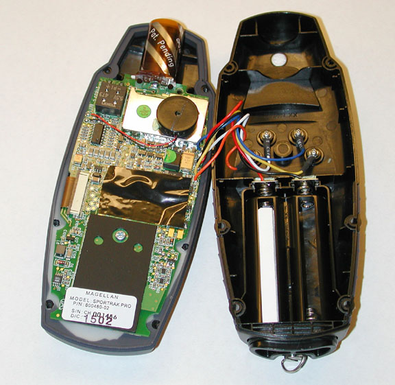
Receiver Case:
One of the first things we noticed was
that the case is held together with six screws. For those with 'insane
curiosity' and need to look inside the unit, the picture below will save
you the trouble. The case is well constructed with parts adequately
sealed. Magellan says it meets the waterproofness specification of
IPX7.