Reviewed by Joe Mehaffey and Jack Yeazel
(18 Sept. 2001 - See: Altitude)
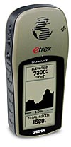
Etrex Summit
The eTrex is Garmin's "beginner's GPS receiver" with simplified features and controls and offering the lowest weight we have seen at under 6 ounces. We especially like the small "shirt pocket comfortable" size. However, the eTrex Summit, in the same package, has a number of new and unique features.
What's New and Different in the eTrex Summit?
The Garmin eTrex Summit ($210 v. 2.05), check latest prices (HERE), is an upgraded eTrex package with the addition of a built-in electronic compass which shows your receiver heading even when you are not moving. An altitude profiling system will show a profile of your elevation movement along your route of travel. These new features are made possible by a built-in electronic flux-gate compass, and barometric altimeter. The compass is calibrated by the user turning around slowly twice in an interference-free area. The altimeter and GPS altitude are constantly filtered to provide the best measure of altitude. All key controls are on the sides, leaving the front area free for display and antenna.
COMPASS: The compass display changes from direction-traveled to direction-pointed depending on a user-selectable minimum speed and time. In the Setup, Units, Angle, the compass readings and GOTO bearings can be set to either degrees or mils.
As for the flux-gate, the Summit outputs a new NMEA Sentence, $HCHDG, which contains Heading and Magnetic Variation. The NMEA sentence data is the same as what the GPS displays. We don't know what the NMEA heading data is when you put the GPS in motion, and the display changes from Heading to Direction Traveled.
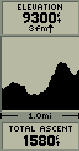
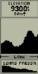
ALTITUDE: Readouts include maximum and average Ascent and Descent distances and rates. The altitude profile can also indicate pressure changes over time. The GPS reads a different altitude than the NMEA output -which reads both higher and lower than the GPS display over even short periods. The displayed altitude stays relatively steady while the NMEA $GPGGA sentence altitude goes up and down. The NMEA $GPGGA is GPS altitude only (in meters). The barometric altitude is shown in Garmin proprietary NMEA sentence $PGRMZ (in feet). Garmin says the tracklog altitudes are from the pressure altimeter, and our tests confirm it.
BAROMETER:
The SUMMIT barometer is a potentially useful
for some people as it is used to compensate for the normal
fluctuations in GPS altitude. However
it has some problems, because it causes Altitude to not readout properly
in
pressurized airplanes. Although the
unit's
barometer is supposedly corrected by the GPS altitude, there is no
evidence that this is so. For example,
if one increases altitude, the Normalized pressure goes DOWN (and vice
versa) when the Normalized pressure has actually
not changed at all. Also, one cannot read the GPS altitude on a
continuous basis. Read Garmin's explanation
of the barometer (HERE).
All these barometer problems have been corrected in the GPSmap 76S which
you can read about (HERE).
TRACKLOGS: The Summit records a trackpoint every two seconds, and this isn't adjustable. But it has the highest-resolution tracklogs while walking of any Garmin receiver. See plots (HERE). This higher resolution will limit recording Active tracklogs (while walking) to about eight miles, and city driving to about 150 miles. However, the Active log of 3,000 trackpoints can be saved 10 times to 500-trackpoint tracks. As of this writing, the saved tracklogs cannot be displayed on the Map page. We are looking into this. One saved track at a time can be converted to a Trackback and displayed on the Map page.
A word about Calibration
Compass:
To get the best possible accuracy from the compass, one must find
a level surface in a magnetic field free surrounding and turn the
compass around slowly on this surface two times. If not level while
calibrating, the inclination of the magnetic field will cause the calibration
to be in error.
Altimeter:
There is no (real) need to calibrate the altimeter. In about
an hour, the GPS and the pressure sensor will "Auto Cal". In fact
setting in the local barometric setting with Auto Cal ON doesn't seem to
overcome the GPS altitude error. Calibrating at a known altitude
will result in a short-term improvement.
With Auto Cal OFF, the altimeter will act just like any barometric altimeter (i.e. independent of GPS altitude) where the long term accuracy is dependent on weather and how well the the actual change in pressure with height follows the standard model the altimeter uses. "Ambient" (local) pressure is not used by any authority, like the FAA, that we know of.
Garmin explains:
The Normalized (sea level) pressure
will be stored and will actually default in the calibration screen if you
choose to set the altimeter by baro, vs. known altitude. We strongly
recommend that the unit be routinely calibrated against a known altitude
for the greatest accuracy. The user should also use a
known pressure reading or known altitude for initial calibration as the
initially displayed Normalized pressure may not be accurate until calibration
is complete.
If the Summit has been turned off for approx. 3 hours (cumulative) or more since the last manual altitude calibration, it will take a minimum of 5 minutes to start auto-calibration and up to 30+ minutes to see significant changes. The latter is due to the need for multiple samples, etc. Since you are calibrating from GPS data, all of the usual GPS position fix requirements will apply. You will need good geometry, signal strength and so on before the auto-cal feature will register noticeable change.
What about Summit's regular GPS features?
eTrex Summit (and eTrex) are designed with a new "non technical" GPS user in mind. It is designed with simplified controls, simplified and reduced features and generally seems intended for a "new GPS user" with no GPS experience. (A complete list of features may be found below.)
Many less used features (or features Garmin considered non-essential) and displays are not present in eTrex or Summit. Features such as cross track error, pan and scan, POI/city database, battery hours timers, user timers, and uploadable maps are among the missing. Some of these would be difficult to use with only the FOUR operating keys (page, up, down, and enter plus the POWER switch) but just having four keys does make it easy to use.
Well.. What do we think about eTrex Summit?
eTrex Summit is sort of a dilemma for us. Although we don't normally review non-mapping GPSs, the unit has useful and interesting elevation profiling features that will be of great interest and use to hikers, glider and soaring enthusiasts, private pilots among others. These features include a "trip profile" in elevation much the same as your bread crumb trail gives you an (x,y) profile of your horizontal travels. In addition, altitude data is stored as a part of the tracklog so you can do post trip analysis on your voyage in (x,y,z) coordinates. This is GREAT stuff.
On the other hand, the "not included" features we like to use in a more standard version GPS such as the G-12xl fill a pretty good list. They include: external antenna port, trip timers, cross track error, POI/city data points, pan & scan, waypoint averaging, multiple user adjustable screen formats, internal wide range voltage regulator, and is also missing a range of additional display screens and features compared with (say) the G-12xl, G-12Map, etc. Beginning with version 2.02 firmware, eTrex Summit 2.07 now has 20 route capability. (eTrex 2.10 still has just one route.)
Is it a quality, and functional GPS receiver for Hiking and Automobile use?
Yes. We do agree that eTrex with its reduced feature set is easy to learn, easy to use and fully functional in getting you from A to B. It is accurate and provides the essential functionality for hiking use. The latest version of eTrex and eTrex Summit has 20 routes with 50 points each. Also unique is the 3,000 trackpoint storage capability. Saved tracklogs can also double as Trackback routes once you have been along the desired path one time. The extremely small package coupled with good battery life is a plus. eTrex and eTrex Summit both have a computer interface so a user can operate it with a mapping program such as Street Atlas 7/8, GARtrip, G7ToWin, or OziExplorer. Note: Presently, eTrex does NOT have the Garmin PVT protocol interface to computers while the eTrex Summit does have PVT protocol. We are advised that eTrex will be updated in a future firmware release to incorporate the PVT protocol.
What about RF sensitivity and use under tree cover?
I noticed in comparative testing that our test Summit unit seemed
to be less sensitive than some other Garmin receivers. Not much,
maybe 2 to 3 db is our estimate. I questioned Garmin engineering
on this and was provided data which indicated that, if anything,
eTrex Summit should be a bit more sensitive than other units. It
is suggested that our prototype unit may not be "up to specs". I
ran a small survey of news group members who owned BOTH eTrex and another
Garmin receiver and by about a 4/1 margin (just 12 responders), users
report that eTrex has very slightly less sensitivity than other Garmin
units. Frankly, I would suspect this simply because of the
slightly smaller antenna aperture but only by a few db.
Experiments under tree cover show the eTrex to be roughly identical performance with other Garmin receivers in most situations.
Is eTrex Summit ROBUST? Is it WaterProof?
The Summit is indeed a robust GPS receiver and like other Garmin units in current production, it is rated for submersion to 1 meter for up to 30 minutes. We did not try the submersion but Garmin has a reputation of replacing or repairing any unit found to leak. Summit seems particularly robust and several drops to the floor or ground did not faze it.
There has been discussion as to the degree of "waterproofness" of Garmin GPS receivers and especially the eTrex and Summit. Here is Garmin's statement on waterproofness:
Garmin reports: "Our specifications for eTrex are that it is waterproof per IEC529-IPX7. IEC is a European specification published by the International Electrotechnical Commission. It is very similar to the Japanese Industry Standard JIS-8. IEC529 gives an excellent breakdown of the relative degrees of protection against water ingress. (A layman's breakdown of IEC529 can be found HERE.) By the way, our products are more waterproof than virtually everyone else's. We even test 100% of them in our factory. It costs a lot more, but we do it anyway to be sure what we ship meets IPX7. We understand and acknowledge that the marine environment can be very harsh. Even the brass contacts with nickel plating and gold over that will eventually corrode if left exposed to sea water long enough. That's the best contact material available, and we use it on all our external power contacts. All other marine electronic products in the $100-$500 class that we are aware of have this weakness. IEC529 specifies that the immersion test is to be done in fresh water, probably for this reason. The harsh environment does occasionally cause failures and we continually work on improvements to existing products while introducing new ones."
"The classification of IPX7 is for temporary (i.e. accidental) immersion
in water. It is not for continuous underwater use. If the end
user is looking for something that can be used underwater continuously,
they need to find something rated IPX8 or JIS8. However, we are not
aware of any GPS or fish finder that is rated for IPX8 in any price category.
You will see in the attached sections of IEC529, that "The manufacturer
of the equipment should be consulted to determine the degrees of protection
available and the parts of equipment to which the stated degree of protection
applies." We recently did start to add to our packaging a note concerning
the extended waterproofness of our battery compartments as the seal is
rubber and over time and wear and tear, will not be able to maintain as
good of a seal as when new. We have a vested interest in presenting
truthful, correct information to all of our current and potential customers."
(End of Garmin statement.)
ETrex Summit Features Highlights
Elevation Profiling features
Elevation Profiling
features are not available in any other consumer GPS receiver that we have
reviewed.
- Real time plot over time and distance (screen
photo here)
- Zoom in/out elevation profile
- Review individual elevation points with time and date
- Current ascent/descent rate
- Total ascent/descent (resetable)
- Average ascent/descent rate
- Min/Max ascent/descent rate (resettle)
- Min/Max elevation (resetable)
Barometric Altimeter Features
- Accuracy: 10 feet with proper calibration (user and/or automatic
calibration)
- Resolution: 1 foot
- Range: Ð2,000 to 30,000 feet
- Pressure: 12 hour automatic pressure trend recording (screen
photo here)
Sight 'N Go
- Sight and locked in a bearing
- Navigate along course by following CDI with off course information
(screen photo here)
- Sight and project a waypoint, and navigate to it
Track Log
- Automatic elevation and track logging (3000 points)
- Save up to 10 tracks (along with elevation profile) with 500 points
each
- Note: Clearing track log will also clear elevation profile
Options/Settings
- Option to show/hide waypoint
- Option to display heading using big numbers
- Option to set different units for distance/speed, elevation, and
pressure
- Options to turn on/off GPS and Compass (saves power when entering
data)
Electronic Compass
- Accuracy +/- 5 degrees with user calibration
- Resolution 1 degree
- Built in LEVEL sensor aids compass reading accuracy.
- Compass operates in Track UP mode only.
- Automatic Declination adjustment with manual override.
Standard eTrex and eTrex Summit GPS Features: Summit has all standard eTrex features.
- Automatic map rotation (toward your heading, aka Track UP)
or North UP. (Compass disabled in North UP mode.)
- Create new waypoint by projecting from an existing waypoint
- 500 Waypoints (with Icons/graphic symbol, and name)
- 20 reversible routes with up to 50 waypoints in a route.
(ver 2.02 Summit only. eTrex has just one route.)
- Trip Computer with current speed, average speed, sunrise/sunset,
max speed, trip timer and trip odometer
- 100+ map datums
- Position format has Lat/Long, UTM/UPS, Maidenhead, MGRS,
and other grids, one USER grid, and one USER Datum.
- Receiver is 12 channel parallel. Antenna is slightly smaller
than on other units which gives good (but not exceptional) sensitivity
- Receiver update rate is 1 per second.
- No external amplified antenna connection port is available.
- Acquisition Times: Warm ~15 sec, Cold~45 seconds, AutoLocate~2
minutes (Autolocate time was ~ 4 minutes
our one test.)
- eTrex and Summit have only 5 control buttons. This makes
for easy one hand operation.
- Position Accuracy specification 15 meters RMS (seems to do this
routinely with SA OFF)
- Speed Accuracy specification 0.1 knot RMS steady state
- Interfaces: RS232 with NMEA 0183, RTCM 104 DGPS data format and
proprietary GARMIN
- Physical Size: 4.4"H x 2.0"W x 1.2"D (11.2 x 5.1 x 3.0 cm)
- Weight: 6 ounces (170 g) with batteries
- Display: 2.1"H x 1.1"W (5.4 x 2.7 cm) high-contrast LCD (128x64
pixels), FSTN, 4 level gray scale, with bright
backlighting
- Case: Waterproof to IEC 529 IPX7 standards (Immersion to 1 meter
for 30 minutes)
- Temperature range (operation): 5°F to 158°F (-15°C
to 70°C)
- Data storage: Indefinite; no memory battery required
- Power Source: 2 AA batteries ( batteries not included in
package)
- Battery Life: Up to 16 hours (typical use) Note: Use
of the electronic compass runs battery down faster.
Specific questions answered:
How many datums does it have? over 100
Does it support UTM/UPS?
Yes. MGRS? Yes.
How many backlight steps does it have?
2 (on and off) and it times out automatically in 30 seconds.
Does it have user grids? Yes.
Can it measure distance between waypoints
in a route? yes
What is battery life of Etrex? About 20
hours in battery save mode on two batteries.
What is battery life for Etrex Summit?
20 hours in battery save, about 12 hours if compass is turned ON.
Can I upload mapsource maps? No.
What OTHER maps can I upload into my eTrex?
None. eTrex does not support uploadable maps.
Can I use an external antenna? No
(except the Tri-M re-radiating antenna.)
Is there a power/data cable so I
can hook up my computer and external power to the Trex (Summit?)
Yes.
What is the max external voltage
input to eTrex/Summit? Ans.: 3.25 volts DC. (Must have regulator
if used with 12v car.)
What upload/download software works
with eTrex? Ans: MapSource 3.0x, GPS Utility, G7to(Win), TrackMaker
ver10 (to be verified for Summit).
Can I use Delorme Street Atlas 7
with my eTrex? Yes. SA7 supports eTrex/Summit (IF) you have
the LATEST SA7 update.
Questions? Comments? Additional Info we should add?
Contact: Joe Mehaffey
- Jack Yeazel