 ___
___ =====
===== ___
___
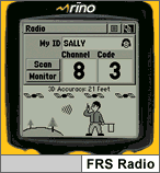
Typical R-110 Screen Pictures (no uploadable maps)
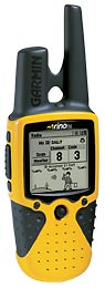
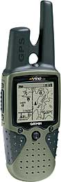
Rino 120 (8 meg map mem), Typical R-120 Screen pictures
(Photos courtesy Garmin International)
___=====___
Typical R-110 Screen Pictures (no uploadable maps)
Rino 120 (8 meg map mem), Typical R-120 Screen pictures
(Photos courtesy Garmin International)
What is the RINO GPS/Radio System?
RINO is an acronym for "Radio Integrated
with Navigation for the Outdoors".
The GPS itself is "akin" to an eTrex Legend, but with changes and
feature additions. What can you do with a Rino that you cannot
do with an eTrex LEGEND? Two or more users with RINO GPS/Radios can
turn on their units, transmit and view on the GPS screen the location of
other RINO users who share the same radio frequency (and privacy tones
if used). Voice communication between Rinos and between Rinos and
radios in the FRS and GMRS radio services (using simplex ONLY) are also
possible using the built in handitalkie. Each RINO is "named" (e.g.
Joe, Jack, Mac, George). The map display will show the name
next to the location of each "on frequency" remote user (see moving display
above.). RINO GPS/Radios (hereinafter, Rino) have a range of
typically less than a mile using FRS (Family Radio Service, A CB
Radio service) and perhaps as much as two miles using GMRS (a service requiring
a
license from the FCC.) Range in the GMRS can be extended
much further in some areas by the use of RADIO REPEATERS in the GMRS service
but UNFORTUNATELY, Rino units cannot transmit on the repeater input frequencies.
The Rino units have radio transmit power of 0.5 watt (FRS) and 1.0 watt
(GMRS). The small radio antenna (longest protrusion above)
provides about ( -7db) gain which results in an ERP (effective radiated
power) of about 200mw on the GMRS frequencies and perhaps 100mw on FRS.
Don't expect lots of "Rino-to-Rino range" with this power level.
Expect car-to-car radio range to be even more limited. Note that
the transmission of position IS NOT automatic and no provision for automatic
transmission of position is available with Rino. (This was a condition
of the FCC authorization to use the FRS frequencies.) A Rino user
must press a button on his unit to transmit his location to other Rino
users on the frequency.
The Rino 120 model pictured above offers a MAPPING capability for both MapSource (R&R, TOPO, World Map, Fishing Hot Spots (limited functionality), and marine maps (limited functionality) and MetroGuide maps. The Rino offers built in (WAAS) which improves position measurement accuracy. The Rino 110 (yellow unit above) offers the same features as the 120 model, but has no memory for user loaded maps. It does have POI, waypoint, route, and track memory similar to other Garmin NON-mapping models such as the eTrex VENTURE.
NOTE: Apparently some Rinos are being delivered with the contrast very low. If you can't read the screen, press the power button once (do not hold) and then move the click stick left or right on the click stick to increase/decrease the contrast level. This will allow you to set the contrast without having to go through the menu sequences.
What's New and Different in the RINO compared with
the eTrex LEGEND?
The Garmin eTrex
RINO 110 (street price ~$165), RINO 120 (street price ~$225),
(LEGEND without radio sells for about $210 by comparison) check latest
prices (HERE),
is an "similar to" eTrex package with the addition of two "prongs".
The larger diameter, shorter prong is the quad helix GPS antenna while
the longer prong is the 465mhz FM radio antenna. RINO has a MY ID
field into which the user inputs his ID for use in transmitting his location
to other RINOs. 22 radio channels and 38 squelch codes are provided.
Certain keys may be "locked" to prevent unwanted keypresses. (Garmin
has put the POWER ON key (See photo above. button is top, center
in front of the antennas) where it will NEVER be pressed by accident!)
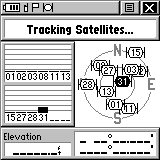
RINO has a status bar (top left of each screen) to indicate many modes
of operation to the user at a glance.
The Satellite page shown indicates that the battery is at about 75%, Radio
is ON, peer-to-peer location is ready to send, and GPS is ON and position
is not ready. However, the symbols are so tiny that good eyesight
is required to make use of this feature. Overall size of the RINO
models is 4.5"Hx2.3"Wx1.6"D, 7"high if the antenna is included. (11.4x5.8x4.1;17.8cm).
Weight is about 7.5 oz (236g) with three Alkaline AA cells included.
Screen size is 1.4"x1.4" (3.6x3.6cm), 160x160 Pixels. The screen
has slightly larger area as compared to the LEGEND screen which is 1.1x2.1inches
(2.56sq in for RINO vs 2.31sq in for LEGEND. Like most other Garmin
handhelds, RINO is rated waterproof to IPX7 which is 1 meter immersion
for 30 minutes. (Note: The IPX7 specification is designed to test
for the ability to ACCIDENTALLY immerse equipment. It is NOT designed
to test if a piece of equipment is suitable to swim with!)
What about Rino's regular GPS features?
The Rino is essentially an eTrex series unit and as such is
designed with a "non technical" GPS user in mind. However,
the Rino has a complete GPS feature set for hiking and motoring (except
for automatic route generation). When MetroGuide maps are loaded,
(R-120 only) a FIND ADDRESS feature allows location of a particular
street address and you can MANUALLY generate a route to this address by
placing waypoints at each intersection on the way and connecting the waypoints
into a route. It is also possible to automatically generate a route using
MapSource MetroGuide and download this route with its waypoints into the
Rino. Standard features of Rino include: Sun and Moon predictor,
Regular and Scientific Calculator, "Best time to hunt and fish",
and Games. Garmin's new Fishing Hot Spots maps is compatible
with Rino 120.
The RINO uses the same sort of "click stick" (rocker/push) switch for most functions as is used in the eTrex LEGEND/VISTA line. However, the switch "feels" much more positive in operation. The click stick protrudes on about 1/16 inch beyond the case and as a result it is difficult (for me) not to PRESS the click stick when you really meant to PUSH Right/Left/Up/Down. I finally figured out that using my fingernail to make sideways motions of the "click stick" rocker and my finger to press down was the ticket (for me). Note: Garmin says that later production models will have a click stick with a longer post to correct this problem.
Operation controls are quite sparse and an extensive menu system is used to allow user control of the (literally) hundreds of features and settings. This works fine but plan to spend some time with the manual and the unit learning where all of the features are located. I found the menu system pretty logical and easy to use, but just don't plan to make settings in a hurry. There is a PAGE key which is used to circulate through various screens such as: MAP, Nav, Radio, Routes, Satellite, StopWatch, Sun/Moon, Tracks, Trip Computer, Main Menu, Alarm Clock (with buzzer/vibrator). Which menus rotate when the PAGE key is pressed are user selectable. By this selection, each user is able to put his most frequently used screens in the page rotation sequence while the rest remain in the main menu for access.
The Rino and other eTrex Series models in general have eliminated the "Remarks" feature from waypoint names. However, the Rino allows 10-character waypoint names as compared to 6 characters in the eTrex and eTrex Summit.
TRACKLOGS: The Rino shares with other eTrex models the highest resolution tracklogs while walking of any Garmin series. See plots (HERE). Compared to the Summit, the Legend default has less walking resolution. However, the Auto tracklog interval can be set to "More Often" or "Most Often" to increase tracklog resolution. Selected saved tracklogs can be displayed on the map page. One saved track at a time can be converted to a Trackback. Note: With Rino, LEGEND, VISTA, and VENTURE, the user has control of the tracklogger as to automatic/time/distance between log points unlike earlier eTrex models. For some tests of the Rino's (like VISTA's) accuracy with WAAS see (HERE). See the TrackLog screen HERE.
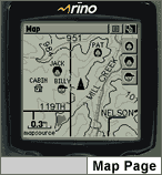
ROUTES and MAPS: Rino 120 can upload ALL of Garmin's digital mapping products. (Rino 110 has no built in our uploadable map capability.) The Rino has no built-in automatic address-to-address routing. However, with Garmin's new MertoGuide USA, MapSource CAN generate automatic address-to-address routes on your external computer which can then be uploaded into the Rino. Delorme SA9 also can provide the address to address routing function for uploading into Rino models. Routes can be loaded into both Rino models, but only the Rino 120 has roadmaps.
Other new features of interest are:
Rino Radio Features
Rino has a low power radio transmitter and a compact antenna.
Effective Radiated Power is estimated at about 200 milliwatts or less.
The antenna has a gain in the range of minus 7db. The radio transmits
and receives in the frequency range of 467mhz and has a range of
one mile or less on FRS channels (ch 1 to 14), 500mw transmit power, 100mw
ERP, and two miles or less on GMRS channels (ch 15 to 22), 200mw ERP.
You are able to operate your Rino as a handitalkie on all 22 channels (provided
you have a license for the GMRS frequencies). If you try and operate
a couple of units between two enclosed metal boxes (aka automobiles), you
will get considerably LESS range. Rino can operate simplex
(transmit and receive on the same frequency) on the FRS band and on the
GMRS band. Rino CANNOT operate on GMRS repeaters and no facility
is provided to enable Rino to transmit on GMRS input frequencies.
You CAN operate simplex on the GMRS channels. If you do not have
authorization and know what you are doing, stick to the FRS channels.)
Note also: DO NOT OPERATE UNLICENSED on channels 15 through 22. The FCC
can fine unlicensed operators up to $10,000 per day for unlicensed operation
on these bands.)
Rino has a unique "peer-to-peer" tracking capability. With this capability, two users in radio contact on the FRS BAND (only) can know precisely where the other is by keying up the transmitter and his location will appear on the MAP screen of other cooperative units on the same channel. Rino users can also LOG contacts with other users in an electronic log file. Note: FCC rules DO NOT permit data transmission on the GMRS bands. No.. We do not know how to modify a RINO so it will send data on the GMRC bands.
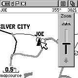
There is a bevy of special map and screen symbols used by the new radio capability. The user enters his ID (name) and may select a symbol so as to uniquely show up on other Rino map screens when interrogated. The map HERE shows on Jack's MAP SCREEN the location of Joe. Rino radio features which can be turned on or off by the user include: Call Tone (sends attention tone to others), Roger Tone (Issues when the talk switch is released.), Ring Tone (Receiving Radio sounds tone when it receives a call on its channel and with the proper tone (when used), Vibrator (Operates on (initial and at 45 second intervals) incoming transmissions), Scramble (allows limited privacy of communication ON THE R-120 ONLY), VOX (when used with external hands free mic/earphone allows "speak to transmit" operation of the radio, Send Location (when activated, button sends current location to other units. There is a visual information screen on the radio page that (upon first glance) will take your breath. It is quite complex but after spending a few hours with it, you begin to remember what the various symbols mean and after that it is pretty neat.
The Rino has a 500 waypoint capability. The "contact log" uses
one of these waypoints each time a remote user calls in. These contact
log points are plotted on the map so the receiving station can plot the
progress of the remote station.
Software Compatibility
The following programs are compatible with Garmin's data transfer
protocol: MapSource 3.0x, Street Atlas 8, National Geographic Topo!,
Fugawi, MacGPS Pro, Ozi Explorer, G7ToWin, GARTrip, GPS Utility, and TrackMaker
Ver. 10. NMEA output is 0183 Ver 2.3.
NOTE: Only Garmin maps in conjunction to MapSource are uploadable
to Garmin mapping GPS receivers. No maps from any other vendor
besides Garmin can be loaded INTO any Garmin GPS. (Same with other
consumer GPS vendors.) No Scanned Map from any third party source
can be loaded into any Garmin GPS receiver (Same with other consumer GPS
vendors.) No USGS DRG map can be loaded. Delorme SA map products
cannot load maps into any vendor's GPS receiver.
Well.. What do we think about Rino units?
Jack and I are pretty happy with these new models. I have
sometimes "fussed" at Garmin for designing a GPS and leaving out some very
desirable feature. Garmin did not do that on Rino. Rino offers
almost everything a hiker/motorist needs to navigate. The only missing
ingredient for motorists is automatic address-to-address routing which
is available in the Garmin ColorMap StreetPilot III. The FIND (address/intersection/city/etc.)
feature works as a nice substitute when used with MetroGuide maps.
For hikers, we think Garmin has gone 100% and these units have all
essential features and more.
Rino units offer a wide range of useful features and or major criticism is in the usability of the click-stick used for most data entry. Functionally, the rocker switch is a major improvement from the older eTrex and Summit EXCEPT that it barely protrudes from the case 1/16 inch and so (for us) it was almost impossible to input data by pushing the click stick up/down/right/left with your finger friction on the top of the stick. Instead, we had to routinely use our fingernail or some other "probe", such as a pen, to avoid pushing DOWN on the clickstick (give ENTER function). We must say, that an almost unbelievable functionality has been built into the Rino and to control it (mostly) through the clickstick is nice. We wish it stuck up higher as on the LEGEND and VISTA. (Late note: We understand that later production Rino Click Sticks do protrude higher out of the case.) We still miss the full page "highway" display of cross track error which is most useful in flying and marine uses but Rino does offer a cross track error feature.
On the other hand, the "not included" features we like to use in other Garmin GPS versions include: external antenna port, waypoint averaging, and internal wide range voltage regulator. Map memory is 8 megs in Rino and is NOT expandable. In compensation, no competing consumer GPS has a capability of 20 routes with 50 waypoints in each route (except other eTrex models).
WAAS: What is it and why would I want it.
WAAS is a position accuracy enhancement system being tested (now)
for full deployment (in years to come) as a safe and reliable source of
differential corrections and integrity monitoring for aircraft navigation
system using GPS. (See more information on WAAS (HERE).
In our "casual" testing, we found that the LEGEND gave us routinely
accurate measurements only as long as there were no surrounding trees.
There were many "outliners" in this environment out to about 42 feet.
(That is why GPS accuracy is specified as 95% confidence.)
This accuracy with a good strong WAAS signal CLEAR OF TREES was about the
same error as compared to a DGPS equipped consumer model GPS receiver.
Note: Tests were made with the LEGEND and VISTA, but the Rino has
essentially the same receiver and functionality.
Note Carefully: Your geographic location and terrain has EVERYTHING to do with WAAS working for you. The availability of a WAAS satellite and data available is shown by a "D" on each satellite signal bar where satellite WAAS correction data is available. Presently there are only TWO WAAS satellites. ( Garmin units allow for 19 WAAS/EGNOS/MSAS unique GEO satellites as specified by the FAA. They are depicted on the GPS as Satellite ID 33-51 which is actually a NMEA convention. Each WAAS/EGNOS/MSAS satellite will have its own unique PRN code assigned from the list of 19.) Sample plots of WAAS accuracy with the VISTA are shown (HERE).
One of these is low on the SE horizon from the Eastern USA and the other low on the SW horizon in the Western USA. If you cannot see at least ONE of these WAAS satellites, WAAS will not operate. You can forget WAAS coverage at present in tree cover, mountainous terrain, or city canyons or in any other situation where you do not have a CLEAR view of one of the two WAAS satellites. Note: The FAA is expected to provide additional WAAS signals in the future, but NO TIME FRAME for these additions has been established as of February 2001. In "northern and middle America" Garmin advises that WAAS operation may be spotty at best until the FAA provides additional satellite signals. WAAS on the Rino at this time is not available with Europe's EGNOS, nor is it available outside the USA.
WAAS in a nutshell: It works just fine when you are in the clear with a good view of the WAAS satellites. When you do NOT have a CLEAR view of one of the WAAS satellites, your Rino (or Legend or Vista) will operate as an ordinary GPS. You should generally turn WAAS off to save power when you do not have a clear view of the sky to the SE or if you are outside the USA as WAAS ON outside the USA or when you do not have a clear sky view may acutally degrade accuracy.
Is it a quality, and functional GPS receiver for Hiking
and Automobile use?
Yes. We do agree that Rino is <fairly> easy
to learn, easy to use and fully functional in getting you from A
to B. Coupled with the radio features, it is NOT as straightforward
to learn as a LEGEND. It is accurate and provides all necessary
functionality for hiking use. Rino has 20 routes with 50 points each and
up to 500 waypoints. Rino has a 2048 (statements elsewhere saying
it has 3000 are in error) trackpoint storage capability and you can save
up to 20 compressed tracklogs with up to 250 points each. Saved tracklogs
can also double as Trackback routes once you have been along the desired
path one time. The extremely small package coupled with average
battery life. Battery life was measured at 15 hours for Rino with
both GPS and Radio turned on. Garmin specifies GPS only, 28 hours,
Radio only, 20 hours.
Rino has a computer interface (with a connector similar to the round connector in G-12xl BUT lots smaller) so a user can operate it with a mapping program such as Street Atlas 7/8, GARtrip, G7ToWin, or OziExplorer.
What about RF sensitivity and use under tree cover?
I noticed in comparative testing that our test Rino unit seemed
to be somewhat more sensitive than some other Garmin eTrex receivers and
seems on a par with other larger units. The quad helix antenna (housing)
appears a bit larger than usual. Experiments under tree cover
show all the eTrex models to have roughly identical performance with
other Garmin receivers in most situations.
Is Rino ROBUST? Is it WaterProof?
The Rino is indeed a robust GPS receiver and like other Garmin units
in current production, it is rated for submersion to 1 meter for
up to 30 minutes. We did not try the submersion but Garmin has a
reputation of replacing or repairing any unit found to leak. Rino seems
particularly robust and well sealed.
There has been discussion as to the degree of "waterproofness" of Garmin GPS receivers and especially the eTrex and Summit (Legend and Vista use essentially the same package). Here is Garmin's statement on waterproofness:
Garmin reports (from a past review): "Our specifications for eTrex (and Rino) are that they are waterproof per IEC529-IPX7. IEC is a European specification published by the International Electrotechnical Commission. It is very similar to the Japanese Industry Standard JIS-8. IEC529 gives an excellent breakdown of the relative degrees of protection against water ingress. (IEC529 specification can be found HERE.) (A layman's breakdown of IEC529 can be found HERE.) By the way, our products are more waterproof than virtually everyone else's. We even test 100% of them in our factory. It costs a lot more, but we do it anyway to be sure what we ship meets IPX7. We understand and acknowledge that the marine environment can be very harsh. Even the brass contacts with nickel plating and gold over that will eventually corrode if left exposed to sea water long enough. That's the best contact material available, and we use it on all our external power contacts. All other marine electronic products in the $100-$500 class that we are aware of have this weakness. IEC529 specifies that the immersion test is to be done in fresh water, probably for this reason. The harsh environment does occasionally cause failures and we continually work on improvements to existing products while introducing new ones."
"The classification of IPX7 is for temporary (i.e. accidental) immersion in water. It is not for continuous underwater use. If the end user is looking for something that can be used underwater continuously, they need to find something rated IPX8 or JIS8. However, we are not aware of any GPS or fish finder that is rated for IPX8 in any price category. You will see in the attached sections of IEC529, that "The manufacturer of the equipment should be consulted to determine the degrees of protection available and the parts of equipment to which the stated degree of protection applies." We recently did start to add to our packaging a note concerning the extended waterproofness of our battery compartments as the seal is rubber and over time and wear and tear, will not be able to maintain as good of a seal as when new. We have a vested interest in presenting truthful, correct information to all of our current and potential customers." (End of Garmin statement.)
Rino GPS Features and Specifications:
Specific questions answered:
Technical Questions? Comments? Additional Info we should add?
For: How Do I operate my GPS? See:
news:sci.geo.satellite-nav
Contact: Joe Mehaffey
CLICK HERE to RETURN to Joe and Jack's GPS Information Website